place

Rich Neck Farm

Farms on the National Register of Historic Places in VirginiaGeorgian architecture in VirginiaHampton Roads, Virginia Registered Historic Place stubsHouses completed in 1802Houses in Surry County, Virginia
Houses on the National Register of Historic Places in VirginiaNational Register of Historic Places in Surry County, Virginia
Rich Neck Farm building and combine

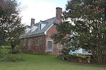
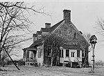
Rich Neck Farm, also known as Richneck Plantation, was a historic home and farm located near Surry, Surry County, Virginia. The house was built about 1802, and was a 11⁄2-story, five-bay, double pile, central-hall plan brick dwelling in a pre-Georgian style. It had a gambrel roof with dormers and sat on a high basement. Long connected with the Ruffins, one of the prominent families of Southside Virginia, Rich Neck possessed a collection of buildings which were among the best preserved and most noteworthy of their type in the region. Original sashes, most of the doors, hinges (many with their leather washers), locks, and other hardware remained. The Ruffin family figured in Virginia's social and intellectual history throughout the colonial and early national periods. Its most notable member was Edmund Ruffin, an ardent secessionist and agricultural pioneer who is considered to be the father of agronomy. Research indicates Rich Neck remained in the Ruffin family until 1865. The house long stood vacant and in a state of disrepair. In 2011 Preservation Virginia listed Rich Neck Farm as one of the most endangered historic sites in Virginia. The house was destroyed by fire in 2012. Also on the property are two contributing granaries, a smokehouse, office, an outhouse, a well house, and a chicken house.Rich Neck Farm was listed on the National Register of Historic Places in 1980.

Excerpt from the Wikipedia article Rich Neck Farm (License: CC BY-SA 3.0, Authors, Images).

Rich Neck Farm
Chippokes Farm Road,

Geographical coordinates (GPS) Address Nearby Places
placeShow on map

Wikipedia: Rich Neck FarmContinue reading on Wikipedia

Geographical coordinates (GPS)

Latitude Longitude
N 37.125833333333 ° E -76.751388888889 °
placeShow on map

Address

Chippokes Farm Road 1579
23883
Virginia, United States
mapOpen on Google Maps

Rich Neck Farm building and combine
Share experience

Nearby Places

Old Brick Church (Bacon's Castle, Virginia)

Old Brick Church (Lower Church, Southwark Parish) variously known as the Lawnes Creek Parish Church or the Lower Surry Church is a historic church in Bacon's Castle, Virginia. The lower chapel of the Southwark Parish was a brick rectangular room church built in 1754 about a mile northwest of Bacon's Castle, in Surry County, Virginia. Its brick walls are irregularly laid in Flemish bond and English bond with a few glazed headers. The church remained abandoned from the Disestablishment of the Church of England in America until 1847. It was destroyed by a fire, reputedly set by recently freed slaves following the American Civil War in 1868, but its thick brick walls remained standing. Its ruins were added to the National Register of Historic Places in 1986. The Old Brick Church was typical of the Virginia vernacular churches of the colonial period. Prior to its destruction it probably resembled other surviving 18th century brick rectangular room churches in Virginia such as the circa-1743 Merchant's Hope Church in Prince George County and the Ware Parish Church in Gloucester. Its walls were fairly well preserved until 2003, when a large oak tree in the churchyard was uprooted by high winds during Hurricane Isabel and fell on the ruins of the church, collapsing large portions of its walls. The ruins have since been stabilized, and many of the original bricks were saved. There are plans to reconstruct the walls and restore the church to its colonial appearance. According to local folklore going back more than a century, the ruins of the Old Brick Church are said to be haunted. Many credible people young and old over several generations claim to have seen the flying fireball. Those who have seen it describe it as simply a ball of fire. It rises from the church cemetery into the air about forty feet and slowly drifts across the broad fields towards Bacon's Castle. A former owner of the plantation saw the fireball out of his window and rushed outside thinking his barn was ablaze. Another person staying at the 17th-century Jacobean mansion woke up to find the ball circling his bed before flying back out the window. Many years ago a church meeting was being held outside in the graveyard and everyone in attendance claimed to have seen the ball of fire.

Cobham, Surry County, Virginia

Cobham was a small town in Surry County, Virginia. It was established by an Act of the Virginia House of Burgesses in 1691, when each county in the Virginia Colony was directed set aside 50 acres (200,000 m2) of land for a town. Storehouses were to be built for products imported and tobacco to be exported. It was ordered that the county sell half-acre lots for its citizens to inhabit the town. It was located at the mouth of Gray's Creek at the James River across and somewhat downstream from Jamestown. It was probably named for Cobham, in Surrey, England. Cobham was active during the 18th and early 19th centuries, but eventually became one of the Former counties, cities, and towns of Virginia. According to the Surry County Historical Society, "today there is little evidence of the town, which became mostly farmland." The society reports that "farmers, while plowing the fields, have run into old foundations, as well as finding locks, broken china, and even a long-barreled pistol." There is also a Cobham in eastern Albemarle County, Virginia. It is located at the intersection of Route 22 (Louisa Road) and Route 640 (St. John's Road / Cobham Station Lane), roughly halfway between Charlottesville and Louisa. The unincorporated community consists of horse farms and homes. Cobham had a train station until the early 20th Century, and one building remains next to the train tracks, thought to have been a feed store. The old train station building was moved to another site near Gordonsville where it is used as a home. The original one-story general store near the tracks was moved about two hundred feet up to Route 22, and with the addition of a two-story building in 1936, served as the Cobham General Store and Post Office until the mid-1990s. After serving other purposes, such as a tack store and internet business, the building was converted to a home in 2002.