Port Glasgow

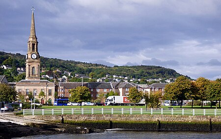
Port Glasgow (Scottish Gaelic: Port Ghlaschu, pronounced [pʰɔrˠʃt̪ˈɣl̪ˠas̪əxu]) is the second-largest town in the Inverclyde council area of Scotland. The population according to the 1991 census for Port Glasgow was 19,426 persons and in the 2001 census was 16,617 persons. The most recent census in 2011 states that the population has declined to 15,414. It is located immediately to the east of Greenock and was previously a burgh in the county of Renfrewshire. Originally a fishing hamlet named Newark, Port Glasgow came about as a result of large ships being unable to navigate the shallow and meandering River Clyde to the centre of the city of Glasgow. As a result, it was formed as a remote port for Glasgow in 1668 and became known as 'New Port Glasgow', which was shortened to 'Port Glasgow' in 1775. Port Glasgow was home to dry docks and shipbuilding beginning in 1780. The town grew from the central area of the present town and thus many of the town's historic buildings and people are found here. Port Glasgow expanded up the steep hills inland to open fields where areas such as Park Farm, Boglestone, Slaemuir and Devol were founded. This area has subsequently become known as upper Port Glasgow and most of the town's population occupies these areas.
Excerpt from the Wikipedia article Port Glasgow (License: CC BY-SA 3.0, Authors, Images).Port Glasgow
Princes Street,
Geographical coordinates (GPS) Address Nearby Places Show on map
Geographical coordinates (GPS)
| Latitude | Longitude |
|---|---|
| N 55.934 ° | E -4.6906 ° |
Address
Princes Street
PA14 5JD , Devol
Scotland, United Kingdom
Open on Google Maps


