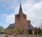
Panheel
Limburg (Netherlands) geography stubsMaasgouwPopulated places in Limburg (Netherlands)

Panheel is a village in the Dutch province of Limburg. It is a part of the municipality of Maasgouw, and lies about 9 km south-west of Roermond. The village was first mentioned in 1417 or 1418 as Panhedel. The etymology is unclear.Panheel was home to 175 people in 1840. In 1875, a chapel was built. Panheel was never elevated to a parish, however it is considered a village by the municipality.The Boschmolenplas is a lake which formed as a result of gravel excavation. It has a diameter of 1 kilometre (0.62 mi) and has clear water with a visibility of 12 metres. It is therefore, a popular diving spot.
Excerpt from the Wikipedia article Panheel (License: CC BY-SA 3.0, Authors, Images).Panheel
Pater Jac. Schreursweg, Maasgouw
Geographical coordinates (GPS) Address Nearby Places Show on map
Geographical coordinates (GPS)
| Latitude | Longitude |
|---|---|
| N 51.183333333333 ° | E 5.8666666666667 ° |
Address
Pater Jac. Schreursweg
Pater Jac. Schreursweg
6097 NH Maasgouw
Limburg, Netherlands
Open on Google Maps


