Stockport Rural District
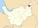
Stockport was a rural district in the administrative county of Cheshire from 1894 to 1904. The district was the successor to the Stockport Rural Sanitary District formed in 1875. The rural district was originally composed of eight civil parishes (with population in 1891): Bosden (2,342) Bramhall (3,365) Brinnington (7,061) Handforth (794) Norbury (1,495) Offerton (372) Torkington (294) Werneth, renamed Compstall 1897 (2,587)In 1900 Hazel Grove and Bramhall Urban District was formed from five of the parishes in the rural district (Bosden, Bramhall, Norbury, Offerton, and Torkington). In 1902 Compstall was constituted an urban district, and Brinnington became part of Bredbury and Romiley Urban District. The remaining parish in the district, Handforth, became an urban district in 1904.
Excerpt from the Wikipedia article Stockport Rural District (License: CC BY-SA 3.0, Authors).Stockport Rural District
Dark Lane,
Geographical coordinates (GPS) Address Nearby Places Show on map
Geographical coordinates (GPS)
| Latitude | Longitude |
|---|---|
| N 53.408 ° | E -2.116 ° |
Address
Dark Lane
Dark Lane
SK6 3LH , Romiley
England, United Kingdom
Open on Google Maps


