Morris Island Conservation Area
Conservation areas in OntarioOntario geography stubs

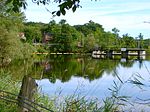
The Morris Island Conservation Area is operated by the Mississippi Valley Conservation Authority.Located on the Ottawa River near Fitzroy Harbour, the Morris Island Conservation Area consists of 47 hectares of forested woodlands and wetlands. It allows for hiking, picnicking, canoeing (within the bay areas of the island), and fishing (including accessible fishing platforms).
Excerpt from the Wikipedia article Morris Island Conservation Area (License: CC BY-SA 3.0, Authors, Images).Morris Island Conservation Area
Causeway Trail, Ottawa
Geographical coordinates (GPS) Address Nearby Places Show on map
Geographical coordinates (GPS)
| Latitude | Longitude |
|---|---|
| N 45.45918 ° | E -76.27138 ° |
Address
Causeway Trail
K7S 3G7 Ottawa (West Carleton-March)
Ontario, Canada
Open on Google Maps


