Poles Coppice countryside site
History of ShropshireIndustrial archaeologyParks and open spaces in Shropshire

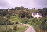
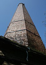
Poles Coppice countryside site is an area of ancient oak woodland with disused quarry workings, located around 0.5 miles (1 km) south of Pontesbury, Shropshire. It is managed by Shropshire Council as a picnic spot and area for walking and recreation activities.
Excerpt from the Wikipedia article Poles Coppice countryside site (License: CC BY-SA 3.0, Authors, Images).Poles Coppice countryside site
Callow Lane,
Geographical coordinates (GPS) Address Nearby Places Show on map
Geographical coordinates (GPS)
| Latitude | Longitude |
|---|---|
| N 52.636 ° | E -2.8999 ° |
Address
Callow Lane
SY5 0DA , Pontesbury
England, United Kingdom
Open on Google Maps


