Peel, Isle of Man
Constituencies of the Isle of ManPeel, Isle of ManPorts and harbours of the Isle of ManTowns in the Isle of ManUse British English from March 2017

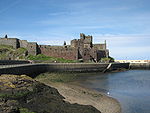
Peel (Manx: Purt ny h-Inshey – Port of the Island) is a seaside town and small fishing port in the Isle of Man, in the historic parish of German but administered separately. Peel is the third largest town in the island after Douglas and Ramsey but the fourth largest settlement, as Onchan has the second largest population but is classified as a village. Until 2016 (when it was merged with Glenfaba) Peel was also a House of Keys constituency, electing one Member of the House of Keys (MHK), who, from September 2015, was Ray Harmer. Peel has a ruined castle on St Patrick's Isle, and a cathedral, seat of the Diocese of Sodor and Man (the diocese was founded when Mann was ruled by the Norse).
Excerpt from the Wikipedia article Peel, Isle of Man (License: CC BY-SA 3.0, Authors, Images).Peel, Isle of Man
Lyndale Avenue,
Geographical coordinates (GPS) Address Nearby Places Show on map
 Continue reading on Wikipedia
 Geographical coordinates (GPS)
| Latitude | Longitude |
|---|---|
| N 54.221 ° | E -4.691 ° |
Address
Lyndale Avenue
Lyndale Avenue
Isle of Man
Open on Google Maps