place

Mayberry Presbyterian Church

Blue Ridge Highlands, Virginia Registered Historic Place stubsBuildings and structures in Patrick County, VirginiaChurches completed in 1925Gothic Revival church buildings in VirginiaNational Register of Historic Places in Patrick County, Virginia
Presbyterian churches in VirginiaVirginia church stubs
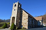
Mayberry Presbyterian Church from southeast

Mayberry Presbyterian Church is a historic Presbyterian church at 1127 Mayberry Church Road in Meadows of Dan, Patrick County, Virginia. It is one of the "rock churches" founded by Bob Childress. It was built in 1925, and is a one-story frame church building faced in natural quartz and quartzite stone. It features Gothic styled lancet windows. The rock facing was added to the frame building in 1948.It was listed on the National Register of Historic Places in 2007.

Excerpt from the Wikipedia article Mayberry Presbyterian Church (License: CC BY-SA 3.0, Authors, Images).

Mayberry Presbyterian Church
Mayberry Church Road,

Geographical coordinates (GPS) Address Nearby Places
placeShow on map

Wikipedia: Mayberry Presbyterian ChurchContinue reading on Wikipedia

Geographical coordinates (GPS)

Latitude Longitude
N 36.712222222222 ° E -80.438888888889 °
placeShow on map

Address

Mayberry Church Road 999
24120
Virginia, United States
mapOpen on Google Maps

Mayberry Presbyterian Church from southeast
Share experience

Nearby Places

Meadows of Dan, Virginia

Meadows of Dan is an unincorporated community and census-designated place in Patrick County, Virginia, where the Blue Ridge Parkway (milepost 178) crosses U.S. Route 58 (Jeb Stuart Highway). It was first listed as a CDP in the 2020 census with a population of 72.There are numerous country shops, classic houses, and restaurants in the community. It is located near the Patrick/Floyd county line about 20 miles east of Hillsville and about 14 miles northwest of Stuart, Virginia. The community's name is credited to one of its earliest English settlers, James Steptoe Langhorne, and comes from the meadows that abound near the Dan River which flows through the area. The community's motto as posted on the welcoming sign is "A simpler place in time". Meadows of Dan is located along the Crooked Road, Virginia and the Crooked Road, Virginia's heritage music trail and in the Rocky Knob American Viticultural Area. The community of Meadows of Dan hosts an annual Folk Fair, in cooperation with the Virginia Peach Festival. Meadows of Dan was also a setting for the ministry of Bob Childress, whose life was chronicled in the book The Man Who Moved a Mountain. The Cockram Mill and Mayberry Presbyterian Church are listed on the National Register of Historic Places. Meadows of Dan is located approximately one half hour north of Andy Griffith’s hometown of Mount Airy, North Carolina, the city which is widely believed to have inspired the fictitious Mayberry on the Andy Griffith Show. It has been speculated that the name “Mayberry” may have come from either Mayberry Road, The Mayberry Trading Post, or the Mayberry Presbyterian Church in Meadows of Dan.

Laurel Fork, Virginia

Laurel Fork is an unincorporated community in Carroll County, Virginia. It is located off U.S. Route 58 and is 12.4 miles (20.0 km) east-southeast of Hillsville, Virginia. Laurel Fork has a post office with the ZIP code 24352.Before the town was known as Laurel Fork, it was called Bolt Town, named after a Doctor Bolt and his numerous family members who originally inhabited the town. Then consisting of Sam Bolt's store, a post office, and a few farms, Bolt Town was nicknamed "Little Cincinnati" because of the perceived superior attitude of its residents. Eventually, the community took its name from the Laurel Fork Creek that winds through the hills nearby, which in turn was named after the native Rhododendron. Early English settlers, not knowing the Rhododendron's name, called it "laurel" after the shrubs they knew from England.Late nineteenth-century census records show that 60 percent of the Laurel Fork population could read and write. Around 1903 - 1904, the Laurel Fork Male and Female Academy was built, later becoming a high school. Businesses including a printing shop, a short-lived motor company, the Laurel Fork Bank, Midway Hotel and Restaurant, Laurel Fork Mercantile, Puckett's Grocery and Garage, as well as the Laurel Fork Telephone Company were also established. Laurel Fork reportedly had the first airport in the county.Among Laurel Fork's surviving historical landmarks is the Laurel Fork Primitive Baptist Church, founded in 1846, making it the oldest church in Laurel Fork and one of the oldest in Carroll County. The church was a daughter church of New Hope Primitive Baptist. The church, as well as a school next to it, were burned down and then rebuilt in 1876 on land given by Mr. and Mrs. Reuben Nester. In 1970, the church was encased in brick and now stands along Laurel Fork Road. Located next to the church is the former Point Pleasant School. Constructed in 1911, this one-room schoolhouse is commonly believed to be the descendant of the first school in Laurel Fork, which had previously burned down. Point Pleasant School closed its doors in 1948. In September 2007, the school was placed on the Virginia Landmarks Register. In October 2007, Point Pleasant School was placed on the National Register of Historic Places.