Vogtei, Thuringia
Municipalities in ThuringiaThuringia geography stubsUnstrut-Hainich-KreisUse British English from June 2023

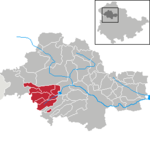
Vogtei is a municipality in the Unstrut-Hainich-Kreis district of Thuringia, Germany. It was formed on 31 December 2012 by the merger of the former municipalities of Langula, Niederdorla, and Oberdorla. The closest town and the only one that it borders is Mühlhausen northerly. The Hainich National Park is situated westerly.
Excerpt from the Wikipedia article Vogtei, Thuringia (License: CC BY-SA 3.0, Authors, Images).Vogtei, Thuringia
Straße zum Mittelpunkt Deutschlands, Vogtei
Geographical coordinates (GPS) Address Nearby Places Show on map
Geographical coordinates (GPS)
| Latitude | Longitude |
|---|---|
| N 51.166666666667 ° | E 10.45 ° |
Address
Straße zum Mittelpunkt Deutschlands
Straße zum Mittelpunkt Deutschlands
99986 Vogtei (Oberdorla)
Thuringia, Germany
Open on Google Maps


