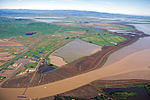
Petaluma River
Estuaries of CaliforniaLandforms of Sonoma County, CaliforniaPetaluma RiverRivers of Marin County, CaliforniaRivers of Northern California ... and 4 more
Rivers of Sonoma County, CaliforniaTributaries of San Pablo BayUse mdy dates from February 2015Wetlands of the San Francisco Bay Area

The Petaluma River is a river in the California counties of Sonoma and Marin that becomes a tidal slough for most of its length. The headwaters are in the area southwest of Cotati. The flow is generally southward through Petaluma's old town, where the waterway becomes navigable, and then flows another 10 mi (16 km) through tidal marshes before emptying into the northwest corner of San Pablo Bay.
Excerpt from the Wikipedia article Petaluma River (License: CC BY-SA 3.0, Authors, Images).Petaluma River
Geographical coordinates (GPS) Address Nearby Places Show on map
Geographical coordinates (GPS)
| Latitude | Longitude |
|---|---|
| N 38.110555555556 ° | E -122.4875 ° |
Address
California, United States
Open on Google Maps


