Palatine Zweibrücken
1459 establishments in Europe1797 disestablishments in EuropeDuchies of the Holy Roman EmpireHistory of the Palatinate (region)House of Palatinate-Zweibrücken ... and 3 more
States and territories disestablished in 1797States and territories established in 1459Western Palatinate

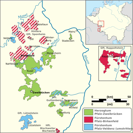
The Duchy of Palatinate-Zweibrücken (German: Herzogtum Pfalz-Zweibrücken; French: Duché de Palatinat-Zweibrücken) was a duchy of the Holy Roman Empire with full voting rights to the Reichstag. Its capital was Zweibrücken. The reigning house, a branch of the Wittelsbach dynasty, was also the Royal House of Sweden from 1654 to 1720.
Excerpt from the Wikipedia article Palatine Zweibrücken (License: CC BY-SA 3.0, Authors, Images).Palatine Zweibrücken
Schloßgartenweg,
Geographical coordinates (GPS) Address Nearby Places Show on map
Geographical coordinates (GPS)
| Latitude | Longitude |
|---|---|
| N 49.25 ° | E 7.3666666666667 ° |
Address
Schloßgartenweg
66482 (Stadtmitte)
Rhineland-Palatinate, Germany
Open on Google Maps


