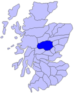
Killiecrankie
Pages including recorded pronunciationsPerth and Kinross geography stubsUse British English from February 2017Villages in Perth and Kinross

Killiecrankie ( ; (Scottish Gaelic: Coille Chreithnich, meaning aspen wood) is a village in Perth and Kinross, Scotland on the River Garry. It lies at the Pass of Killiecrankie, by the A9 road which has been bypassed since 1986. The village is home to a power station forming part of the Tummel Hydro-Electric Power Scheme. Much of the riverbank is owned by the National Trust for Scotland. The nearby 10 arch railway viaduct, which runs for 109 yards (100 m) along the north-east bank of the River Garry, was built in 1863 from a design by Joseph Mitchell.
Excerpt from the Wikipedia article Killiecrankie (License: CC BY-SA 3.0, Authors, Images).Killiecrankie
B8079,
Geographical coordinates (GPS) Address Nearby Places Show on map
Geographical coordinates (GPS)
| Latitude | Longitude |
|---|---|
| N 56.745 ° | E -3.7788888888889 ° |
Address
B8079
PH16 5GZ
Scotland, United Kingdom
Open on Google Maps


