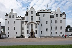
Bridge of Tilt

Bridge of Tilt (Scottish Gaelic: Drochaid Theilt) is a village in Perthshire, Scotland, built around the River Tilt (Scottish Gaelic: Abhainn Teilt), near its confluence with the River Garry. It is 5+3⁄4 miles (9.3 kilometres) northwest of Pitlochry. The newer part of the village is continuous with Blair Atholl, only separated by the River Tilt. The village is located primarily on the B8079 between Pitlochry and Dunalastair Water, but the older part of the village (Old Bridge of Tilt) is located further up the River Tilt. The A9 runs past the River Garry to the south of Bridge of Tilt, and connects the village with Newtonmore and Inverness in the north and Pitlochry, Perth and Stirling in the south.
Excerpt from the Wikipedia article Bridge of Tilt (License: CC BY-SA 3.0, Authors, Images).Bridge of Tilt
Geographical coordinates (GPS) Address Nearby Places Show on map
Geographical coordinates (GPS)
| Latitude | Longitude |
|---|---|
| N 56.771024 ° | E -3.840913 ° |
Address
PH18 5TP
Scotland, United Kingdom
Open on Google Maps


