Sir Wilfrid Laurier Park

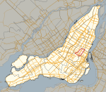
Sir Wilfrid Laurier Park (French: Parc Sir-Wilfrid-Laurier) is an urban park in the Le Plateau-Mont-Royal borough of Montreal, Quebec, Canada. It is bordered by Laurier Avenue East to the south, De Brébeuf Street to the east, Saint Grégoire Street to the north and De Mentana Street to the west. It is crossed by a north–south bicycle path. The path enters the park at Brébeuf Street (corner Laurier) in the south and ends on Christophe Colomb Avenue (corner Saint Grégoire) in the north. The park's area is 10.8 hectares (27 acres). It was named in honor of The Right Honourable Sir Wilfrid Laurier on May 29, 1925. Laurier served as Canada's seventh Prime Minister, from 11 July 1896 to 6 October 1911. The park contains a soccer field, two baseball fields, a public swimming pool, a horseshoes sandbox, a pétanque terrain and a dog park. In the western part of the park, there is a playground with slides, swings and a sandbox for children. The Laurier Centre, located in the heart of the park, is the location of community activities. In winter, it is used as a cottage for skaters.
Excerpt from the Wikipedia article Sir Wilfrid Laurier Park (License: CC BY-SA 3.0, Authors, Images).Sir Wilfrid Laurier Park
Avenue Laurier Est, Montreal Plateau Mont-Royal
Geographical coordinates (GPS) Address Nearby Places Show on map
Geographical coordinates (GPS)
| Latitude | Longitude |
|---|---|
| N 45.5312 ° | E -73.5862 ° |
Address
Avenue Laurier Est 1115
H2J 1H1 Montreal, Plateau Mont-Royal
Quebec, Canada
Open on Google Maps


