place

Mooreland (Brentwood, Tennessee)

Greek Revival houses in TennesseeHouses in Williamson County, TennesseeNational Register of Historic Places in Williamson County, TennesseeResidential buildings completed in 1838Williamson County, Tennessee Registered Historic Place stubs
Mooreland
Mooreland

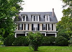
Mooreland is a property in Brentwood, Tennessee that was built c.1838 and that was listed on the National Register of Historic Places in 1975. It was built by Robert Irvin Moore and includes Greek Revival architecture.It is one of about thirty "significant brick and frame residences" surviving in Williamson County that "were the center of large plantations " and display "some of the finest construction of the ante-bellum era." It faces on the Franklin and Columbia Pike that ran south from Brentwood to Franklin to Columbia.

Excerpt from the Wikipedia article Mooreland (Brentwood, Tennessee) (License: CC BY-SA 3.0, Authors, Images).

Mooreland (Brentwood, Tennessee)
Centerview Drive,

Geographical coordinates (GPS) Address Nearby Places
placeShow on map

Wikipedia: Mooreland (Brentwood, Tennessee)Continue reading on Wikipedia

Geographical coordinates (GPS)

Latitude Longitude
N 36.029444444444 ° E -86.788333333333 °
placeShow on map

Address

Hilton Garden Inn Nashville Brentwood

Centerview Drive 217
37027
Tennessee, United States
mapOpen on Google Maps

Mooreland
Mooreland
Share experience

Nearby Places

Nashville Basin

The Nashville Basin, also known as the Central Basin, is a term often used to describe the area surrounding Murfreesboro, Tennessee, in which Nashville is located. The Central Basin was caused by an uplifting which produced a dome known as the Nashville Dome. The Nashville Dome is evidenced by the underlying rock strata that all dip downward away from Nashville. The uplifting of the Nashville Dome fractured overlying strata, making it more easily eroded, and thus the "dome" resulted in a "basin". Uplifted strata in the center of a geological dome have higher potential erosive energy than the surrounding strata, because they are physically higher. Erosion thus acts on the uplifted area at a greater rate than on the surrounding flat-lying area, creating a low area, i.e., a basin. This area is more correctly referred to as the "Central Dome" of Tennessee. Nashville is located in the northwestern portion of the Central Basin. The basin extends for approximately forty-five to sixty miles to the east of Nashville and about eighty miles to the south, near the Tennessee–Alabama state line. Travelers leaving Nashville in a northerly or easterly direction will soon begin the climb up the escarpment that marks the bordering geographic/geologic province, the Highland Rim and further eastwards, the Cumberland Plateau. The southern edge of the Highland Rim is more distant and somewhat less pronounced. The only downhill routes leaving the area follow the course of the Cumberland River as it flows northwest toward Ashland City and Clarksville, Tennessee. The Central Basin is underlain primarily by limestone from the Ordovician Period. The Nashville Basin and a similar but smaller area surrounding Lexington, Kentucky referred to as the "Kentucky Bluegrass" area, are the two primary areas of this sort in the world.The Inner Basin of the flattest terrain and most limestone-derived soil chemistry is located to the south and east of Nashville, primarily in the counties of Marshall, Rutherford, Wilson, and Bedford. Here also are seen the horse farms somewhat reminiscent of the Kentucky Bluegrass region. Supposedly the underlying rock weathers to a soil particularly suited to the growing of the sorts of grasses most favored by horses. Limestone glades (or cedar glades), located to the east of Nashville, primarily in Wilson and Rutherford Counties, are open areas where the flat limestone rock is denuded of overlying soil or nearly so, provide an environment for flora unlike any other in the world.

Nathan Bedford Forrest Statue

The Nathan Bedford Forrest Statue is a 25 feet (7.6 m) equestrian statue of Confederate Lt. General Nathan Bedford Forrest. It was located on private land near Nashville, Tennessee, and was visible from Interstate 65 at 701D Hogan Road. The work, by amateur sculptor Jack Kershaw, was unveiled in 1998. It drew intense controversy and was removed on December 7, 2021. Forrest was depicted shooting behind himself and was flanked by Confederate battle flags. Critics said the work's distorted facial features bore little resemblance to Forrest himself.The statue was owned by Nashville businessman William C. “Bill” Dorris and was located on a narrow strip of property on the east side of I-65 in Nashville. When he died in November 2020, he left the statue in his will to the Battle of Nashville Trust (BONT), a historical non-profit which preserves and maintains portions of the Battle of Nashville battlefield. According to BONT, the statue was disassembled and moved from the site after its removal; it will not be remounted or displayed. In a joint statement issued on that date by the Trust along with the Executor and attorney for the Dorris Estate, the BONT specified the reasons for removal of the statue, noting that “each reason sets aside the contentious debate about Forrest as a person or as a Confederate general:”1. Forrest was not present at The Battle of Nashville. 2. The statue is ugly and a blight on Nashville. 3. It has been vandalized, is in disrepair, and is dangerous. 4. Having the statue in such a prominent location in Nashville distracts from the BONT’s mission and would be and has been divisive in the city we all cherish.In a separate statement, the BONT also noted that "even Forrest himself would think it was ugly,” adding that the Dorris property and statue were not on core battlefield ground. The BONT stressed in its statements that the Forrest statue was not consistent with the historical significance of the Battle of Nashville, which was one of the most decisive of the Civil War and ended the Confederacy’s western campaign, nor was it consistent with BONT’s efforts to protect the remaining historic sites of the battlefield, which currently exist within residential and commercial properties of South Nashville.