place

John Motheral House

1805 establishments in TennesseeHouses completed in 1805Houses completed in 1870Houses in Franklin, TennesseeHouses on the National Register of Historic Places in Tennessee
National Register of Historic Places in Williamson County, TennesseeWilliamson County, Tennessee Registered Historic Place stubs
John Motheral House
John Motheral House

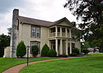
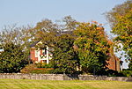
The John Motheral House is a property in Franklin, Tennessee that dates from c.1805, was enlarged c.1870, and was listed on the National Register of Historic Places in 1988. It was built as a log building in c.1805, probably of single pen construction, and was enlarged c.1870 to have an "imposing" two story frame construction. Other Williamson County structures that were enlarged in this way, in approximately the same time period, include the Sherwood Green House and the William Leaton House.

Excerpt from the Wikipedia article John Motheral House (License: CC BY-SA 3.0, Authors, Images).

John Motheral House
Moran Road,

Geographical coordinates (GPS) Address Nearby Places
placeShow on map

Wikipedia: John Motheral HouseContinue reading on Wikipedia

Geographical coordinates (GPS)

Latitude Longitude
N 36.016944444444 ° E -86.898888888889 °
placeShow on map

Address

Moran Road 1299
37069
Tennessee, United States
mapOpen on Google Maps

John Motheral House
John Motheral House
Share experience

Nearby Places

Owl's Hill Nature Center

The Owl's Hill Nature Sanctuary is a 300-acre (1.2 km2) wildlife sanctuary in northwestern Williamson County, Tennessee. Fossil traces in Ordovician limestone and 350-year-old giant trees, vestiges of the great eastern deciduous forest that once covered Tennessee, are important collections on the site, as are pioneer trees and seasonal wildflowers. The ponds and wetlands provide valuable amphibian habitat, home to more than a dozen species. 125 species of birds have been recorded on site through population surveys performed by the National Audubon Society. Nearly all mammals native to Middle Tennessee are in residence at Owl’s Hill. In 1990, an ambitious Master Plan was adopted to restore the natural habitat by overcoming almost a century of farm usage. First, wildlife conditions were improved through removal of several miles of wire fencing; water sources were improved and added; old orchard trees were pruned to restore their productivity. Increases in both predator and prey populations indicate that a healthy ecosystem is now evolving. The second phase included the construction of a trail system, teaching platforms, and remodeling of the visitor center to enhance environmental education programming. Finally, in 2007, the Sanctuary initiated an exotic plant removal project. Native trees, shrubs, wildflowers and grasses are being reintroduced. Emphasis in all these areas continues to expand with current efforts directed at preserving the land surrounding the sanctuary against encroaching development. Through public programs and working with the Land Trust for Tennessee (founded by governor Phil Bredesen) Owl’s Hill has become a focal point for neighboring landowners interested in placing conservation easements on their land. In the fall of 2000, a species inventory was completed. Owl's Hill retained two biologists to undertake a 20-month survey using scientific sampling techniques to document amphibian and reptile populations. Addenda to the inventory catalogue include wildflower, tree, butterfly, bird and mammal populations.

Warner Parks
Warner Parks

Edwin Warner Park and Percy Warner Park, collectively known as Warner Parks, are two major public parks in Nashville, Tennessee. They are part of the park system managed by the Metropolitan Board of Parks and Recreation of Nashville and Davidson County. Percy Warner Park's front entrance is located at the end of Belle Meade Boulevard. The parks are listed on the National Register of Historic Places as Warner Park Historic District. The district is primarily within Nashville along the southern edge of Davidson County, Tennessee, but it extends into Williamson County, Tennessee as well. The two parks are adjacent to each other, separated by Old Hickory Boulevard, and are located approximately 9 mi (14 km) from downtown Nashville. They are bounded on the northwest by Tennessee State Route 100, on the east and north by Chickering Road, and partially on the south by Old Hickory Blvd. and Vaughn Road. The two parks cover 2,684 acres (1,086.2 ha), making the combined parks the second largest municipal park in the state (after Bays Mountain Park in Kingsport which is 3,750 acres). The parks offer a variety of activities, including hiking trails, cross country courses, and an equestrian center.Through funds raised by Friends of Warner Parks, the Warner Parks system added 448 acres in late 2014, expanding the park to more than 3,000 acres. Two properties were purchased for this expansion to enhance the park resources, including the 225-acre Burch Reserve with wooded hills and an old-growth forest previously owned by H. G. Hill Realty. The Burch Reserve is home to Nashville's largest cave in addition to small ponds, meadows and forestry. Ridges and hollows of the former H. G. Hill property are part of what is considered the largest old growth forest in an urban area east of the Mississippi.