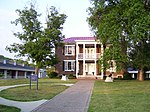
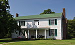
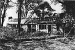
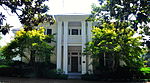
place

Thomas Shute House

Central passage plan architecture in TennesseeGreek Revival houses in TennesseeHouses completed in 1845Houses in Franklin, TennesseeHouses on the National Register of Historic Places in Tennessee
National Register of Historic Places in Williamson County, TennesseeWilliamson County, Tennessee Registered Historic Place stubs
Rosserhouse2
Rosserhouse2

Thomas Shute House is a property in Franklin, Tennessee, United States, that was listed on the National Register of Historic Places in 1988. The property has also been known as Creekside. It dates from at c.1845. When listed the property included three contributing buildings, and two contributing structures on an area of 4.8 acres (1.9 ha). The property was covered in a 1988 study of Williamson County historical resources. It is one of about thirty "significant brick and frame residences" surviving in Williamson County that were built during 1830 to 1860 and "were the center of large plantations " and display "some of the finest construction of the ante-bellum era." It faces on the Franklin and Columbia Pike that ran south from Brentwood to Franklin to Columbia.

Excerpt from the Wikipedia article Thomas Shute House (License: CC BY-SA 3.0, Authors, Images).

Thomas Shute House
Echo Lane, Franklin

Geographical coordinates (GPS) Address Nearby Places
placeShow on map

Wikipedia: Thomas Shute HouseContinue reading on Wikipedia

Geographical coordinates (GPS)

Latitude Longitude
N 35.953055555556 ° E -86.853055555556 °
placeShow on map

Address

Battle Ground Academy

Echo Lane
37069 Franklin
Tennessee, United States
mapOpen on Google Maps

Rosserhouse2
Rosserhouse2
Share experience

Nearby Places

Roper's Knob Fortifications

Roper's Knob Fortifications were constructed by Union Army forces between February and May 1863 in Franklin, Tennessee. According to Tennessee Archaeology, "Roper's Knob served as part of a chain of signal stations that provided a communications link from Franklin to Murfreesboro. Additionally the knob had a large redoubt capable of holding four large artillery pieces, a blockhouse, cisterns, and a magazine. ... "Artillery at Fort Granger, another fortification in Franklin, played a role in the November 1864 Battle of Franklin, but it is believed that Roper's Knob was not then occupied. It is nonetheless believed that artillery had at some point been hoisted into the fortification, in part on the archeological evidence of an artillery fuse found there, but was removed in 1864 when the battlefronts moved south. The area was investigated by an archeological dig in 2000. A letter written by a 22nd Wisconsin soldier - Herman L. Cunningham - on June 28, 1863, from atop Roper's Knob, reveals in part, "Company H, K, & G occupy a Knob about three hundred feet high, with breastworks, stockade, and 125 pounder (cannon). The rest of the Regiment is over to the other fort [Fort Granger] 3/4 of a mile from here, that and the 85th Indiana command this post." The letter header says "Roper's Knob, Franklin."In a study of Civil War Historic and Historic Archeological Resources in Tennessee, it is noted that Winstead Hill, Fort Granger, the Carter House, and Carnton comprise the Franklin Battlefield National Historic Landmark area, but Roper's Knob is not included.: 28  The document describes criteria for listing of fortifications on the National Register of Historic Places which applied to the later Roper's Knob nomination. The property was listed on the National Register of Historic Places in 2000. The listing was for an area of 58.4 acres (23.6 ha).