place

Newton St Cyres

Villages in Devon
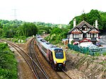
Newton St Cyres geograph.org.uk 164821

Newton St Cyres (, like "sires") is a village, civil parish former manor and former ecclesiastical parish in Mid Devon, in the English county of Devon, located between Crediton and Exeter. It had a population of 562 at the 2011 Census. The village is part of the Newbrooke electoral ward. The ward population at the above census was 1,520. Almost destroyed by fire in the early 1960s, its main point of interest is the Parish Church, built in the 15th century and dedicated to the martyrs St. Cyriac and his mother St. Julitta. Most of the church is in early Perpendicular style, built of local reddish 'trap', a volcanic stone from quarries at Posbury, with the exception of the nave pillars, which are of Beer stone. It contains the monument with standing effigy of John Northcote (1570-1632) of Hayne, lord of the manor of Newton St Cyres. Newton St Cyres railway station is on the Tarka Line from Exeter to Barnstaple and the Dartmoor Line from Exeter to Okehampton, but is located approximately 0.5 miles outside the village centre, and receives an infrequent service. Newton St Cyres is home to a public house, the Beer Engine, which is situated next to the railway station, and an Italian restaurant, Belluno, which was formerly the Crown and Sceptre public house. Traditional cheeses can be bought from the Quickes Farm shop. The village has a recreation ground with two football pitches, a cricket pitch and two tennis courts.

Excerpt from the Wikipedia article Newton St Cyres (License: CC BY-SA 3.0, Authors, Images).

Newton St Cyres
West Town Road, Mid Devon

Geographical coordinates (GPS) Address Nearby Places
placeShow on map

Wikipedia: Newton St CyresContinue reading on Wikipedia

Geographical coordinates (GPS)

Latitude Longitude
N 50.768 ° E -3.592 °
placeShow on map

Address

West Town Road

West Town Road
EX5 5BW Mid Devon
England, United Kingdom
mapOpen on Google Maps

Newton St Cyres geograph.org.uk 164821
Share experience

Nearby Places

Little Fulford
Little Fulford

Little Fulford was an historic estate in the parishes of Shobrooke and Crediton, Devon. It briefly share ownership before 1700 with Great Fulford, in Dunsford, about 9 miles (14 km) to the south-west. The Elizabethan mansion house originally called Fulford House was first built by Sir William Peryam (1534-1604), a judge and Lord Chief Baron of the Exchequer. It acquired the diminutive epithet "Little" in about 1700 to distinguish it from Fulford House, Dunsford and was at some time after 1797 renamed Shobrooke House, to remove all remaining confusion between the two places. Peryam's mansion was demolished in 1815 and a new house erected on a different site away from the River Creedy. This new building was subsequently remodelled in 1850 in an Italianate style. It was destroyed by fire in 1945 and demolished, with only the stable block remaining today. The landscaped park survives, open on the south side to the public by permissive access, and crossed in parts by public rights of way, with ancient large trees and two sets of ornate entrance gates with a long decorative stone multiple-arched bridge over a large ornamental lake. The large pleasure garden survives, usually closed to the public, with walled kitchen garden and stone walls and balustrades of terraces. The park and gardens are Grade II listed in the National Register of Historic Parks and Gardens. The estate was the home successively of the families of Peryam, Tuckfield, Hippisley and lastly the Shelley baronets, in whose possession it remains today.

Exwick
Exwick

Exwick is an historic parish and manor in Devon, England, which today is a north-western suburb of the City of Exeter. Its name is derived from the River Exe, which forms its eastern boundary. It is also an Ecclesiastical parish and an electoral ward. Mentioned in the Domesday Book, it was the site of farms, orchards and mills. Exwick meaning farm by the river Exe. Being on the edge of the Exe floodplain, mill industries were important in Exwick. A leat from the Exe was dug before the Doomsday book was compiled. Other industries formerly in the area include clothmaking, aeroparts and baking. Manufacture of wooden flooring continues to this day. There were a number of large houses in the area including Cleve House which became a Guide Dogs for the Blind training centre in the 1950s. Later it became private houses and the site of a new primary school. The Mallet family bought Exwick Mill.Another important family with an Exwick Connection were the Gibbs. Andrew Gibbs from Clyst St Mary in Exeter, following several adventures, was involved in setting up the Antony Gibbs & Sons cloth business in 1778. William Gibbs paid to make Exwick a separate parish from St Thomas and extend the Chapel of ease into the full church of St. Andrews. The area is often used as a location for painters to look back at Exeter, including Frances Towne in 1773 and J. M. W. Turner in 1811.The murder of Kate Bushell, one of Britain's most high-profile unsolved murders, occurred in Exwick in November 1997.