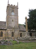
Cropthorne

Cropthorne is a village and civil parish in Worcestershire, England within the Vale of Evesham, and on the North-west edge of the Cotswolds. It is approximately 13 miles (21 km) southeast of Worcester, 19 miles (31 km) north of Cheltenham, and 18 miles (29 km) southwest of Stratford-upon-Avon. Cropthorne has a population of 603, in 237 households (2001 census). Located on a small ridge overlooking the River Avon, its ancient orchards sweep down to the river and offer clear, unbroken views across the vale to the Malvern Hills in the distance. It is featured in the Domesday Book, and St Michael's Church dates back to the 12th century. The church is a Grade I listed building. The village has many unique examples of timber-framed thatched cottages from the 16th and 17th centuries, and about half the village is designated as a Conservation area. The village has a Site of Special Scientific Interest, Cropthorne New Inn Section. Cropthorne has a primary school that serves Cropthorne and the neighbouring village of Charlton. It currently has two pubs The Bell Inn and The New Inn, both offering food and guest accommodation. The village of Fladbury is situated on the opposite bank of the river, and the two communities are linked by the Jubilee Bridge. The Anglican parishes of Fladbury, Hill and Moor and Cropthorne are combined, with a single rector looking after all of the churches. Children from Cropthorne First School, may go on to Bredon Hill Middle School, then Prince Henry's High School in Evesham. Cropthorne has a large playing field (the Sheppey), with a village hall and children's play area. Youth activities centre on the Sheppey Junior Sports Club, which has junior football teams from U9 to U13. An adult football team also plays on the Sheppey. In the year 2000 Cropthorne won the best kept medium village award.
Excerpt from the Wikipedia article Cropthorne (License: CC BY-SA 3.0, Authors, Images).Cropthorne
Middle Lane, Wychavon
Geographical coordinates (GPS) Address Nearby Places Show on map
Geographical coordinates (GPS)
| Latitude | Longitude |
|---|---|
| N 52.101602 ° | E -2.004576 ° |
Address
Middle Lane
WR10 3LZ Wychavon
England, United Kingdom
Open on Google Maps


