place

Lake Tetzitz, Liddow Peninsula and Banzelvitz Hills Nature Reserve

Geography of RügenNature reserves in Mecklenburg-Western PomeraniaNorth Rügen Bodden
NSG Tetzitzer See mit Halbinsel Liddow und Banzelvitzer Berge2155

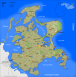
The Lake Tetzitz, Liddow Peninsula and Banzelvitz Hills Nature Reserve (German: Naturschutzgebiet Tetzitzer See mit Halbinsel Liddow und Banzelvitzer Berge) is a nature reserve, 1,088 hectares in area, on the German island of Rügen in Mecklenburg-Western Pomerania. It was officially designated as such on 5 November 1990 and expanded in 1994. Nearby villages are Neuenkirchen and Rappin. The area under protection is a section of the North Rügen Bodden (bodden are shallow lagoons typical of the region) which has a great variety of habitats and is an important roosting and breeding area for the bird world. The elements that give the reserve its name are Lake Tetzitz (Tetzitzer See) in the west, the peninsula of Liddow in the centre and the Banzelvitz Hills (Banzelvitzer Berge) in the eastern part of the nature reserve. Lake Tetzitz is linked to the Großer Jasmunder Bodden by the channel of the Liddow Strom. The reserve is generally in a good condition. The grazed salt meadows are classified as very good. Lake Tetzitz is affected by fertiliser pollution. The nature reserve is protected by EU law as part of the North Rügen Bodden Landscape Special Area of Conservation (FFH-Gebiet Nordrügensche Boddenlandschaft and the Inland Bodden of Rügen Special Protection Area (Vogelschutzgebiet Binnenbodden von Rügen).The footpath from Liddow to Banzelvitz passes through the reserve in places.

Excerpt from the Wikipedia article Lake Tetzitz, Liddow Peninsula and Banzelvitz Hills Nature Reserve (License: CC BY-SA 3.0, Authors, Images).

Lake Tetzitz, Liddow Peninsula and Banzelvitz Hills Nature Reserve
Küstengewässer einschließlich Anteil am Festlandsockel

Geographical coordinates (GPS) Address Nearby Places
placeShow on map

Wikipedia: Lake Tetzitz, Liddow Peninsula and Banzelvitz Hills Nature ReserveContinue reading on Wikipedia

Geographical coordinates (GPS)

Latitude Longitude
N 54.541 ° E 13.36796 °
placeShow on map

Address

Küstengewässer einschließlich Anteil am Festlandsockel


18569 Küstengewässer einschließlich Anteil am Festlandsockel
Mecklenburg-Vorpommern, Germany
mapOpen on Google Maps

NSG Tetzitzer See mit Halbinsel Liddow und Banzelvitzer Berge2155
Share experience

Nearby Places

Großer Jasmunder Bodden

The Großer Jasmunder Bodden belongs to the Northern Rügener Boddens and is a water body on the southern edge of the Baltic Sea in the German state of Mecklenburg-Vorpommern. It is a bodden, a type of lagoon that occurs in northern Europe especially on the coast of Pomerania. It lies within the island of Rügen, is around 14 kilometres long, an average of six kilometres wide and is up to nine metres deep with an average depth of 5.3m. The Großer Jasmunder Bodden has an area of 58.6 square kilometres; if the Breetzer Bodden, Breeger Bodden, Lebbiner Bodden, Neuendorfer Wiek and Tetzitzer See are included the total area of water comes to over 94 square kilometres. The lagoon is bounded to the north by the peninsulas of Wittow and Jasmund, which are linked by the narrow spit of Schaabe. To the south of the bodden is the main body of the island of Rügen, Muttland. To the east near Lietzow it is linked to the Kleiner Jasmunder Bodden by a ditch and sluice gate. The two bodden were first separated in 1869 by the construction of an embankment that now carries the B 96 federal road and the Stralsund–Sassnitz railway. In the west at the Wittow Ferry the bodden has a narrow branch running into the lagoon of Rassower Strom and is thereby linked to the Baltic Sea. The western part of the bodden is further sub-divided into the Breetzer Bodden, Breeger Bodden and Lebbiner Bodden, which, strictly speaking, are not part of the Großer Jasmunder Bodden. The north of the bodden is less divided. Only the Spykersche See near Spyker pushes east forming a small bay. By contrast the southwestern shore is more indented, with the Tetzitzer See and the Neuendorfer Wiek pushing well inland. The extreme southeastern shore of the bodden near Ralswiek is the venue for the Störtebeker Festival that takes place every summer. The water of the Großer Jasmunder Bodden is a mix of fresh water from the streams that discharge into it and the salty waters of the Baltic and is classed as brackish water with a salt content of 0.7 to 0.8 per cent. Almost the entire shore is girt with reeds. In places the shoreline forms sea cliffs that were formed thousands of years ago by breakers in the Littorina Sea, when the islands of Wittow and Jasmund were still not linked by the Schaabe. The bodden is rich in fish and is also used for bathing and sailing. There are important harbours in Ralswiek, Polchow, Breege and St. Martin's Harbour in Sagard.