Camino of Rancho San Antonio
California Historical LandmarksFormer roadsHistory of Oakland, CaliforniaTransportation in Oakland, California

The Camino of Rancho San Antonio is a former road that was located in Alameda County, California. The camino originally reached from Fruitvale to Mission San José. It eventually expanded to travel from the Temescal area of Oakland to San Pablo.
Excerpt from the Wikipedia article Camino of Rancho San Antonio (License: CC BY-SA 3.0, Authors, Images).Camino of Rancho San Antonio
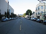
West MacArthur Boulevard, Oakland
Geographical coordinates (GPS) Address Nearby Places Show on map
Geographical coordinates (GPS)
| Latitude | Longitude |
|---|---|
| N 37.824444 ° | E -122.258889 ° |
Address
West MacArthur Boulevard
West MacArthur Boulevard
94609 Oakland
California, United States
Open on Google Maps


