place

Sutter's Fort

1839 establishments in Alta CaliforniaAdobe buildings and structures in CaliforniaBuildings and structures completed in 1839Buildings and structures in Sacramento, CaliforniaCalifornia Gold Rush
California Historical LandmarksCalifornia State Historic ParksDonner PartyForts in CaliforniaHistory museums in CaliforniaHistory of Sacramento, CaliforniaHouses in Sacramento County, CaliforniaHouses on the National Register of Historic Places in CaliforniaJohn SutterLandmarks in Sacramento, CaliforniaMilitary and war museums in CaliforniaMuseums in Sacramento, CaliforniaNational Historic Landmarks in CaliforniaNational Register of Historic Places in Sacramento, CaliforniaParks in Sacramento County, California
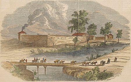
Sutter's Fort from Gleason's Pictorial Drawing Room Companion

Sutter's Fort was a 19th-century agricultural and trade colony in the Mexican Alta California province. The site of the fort was established in 1839 and originally called New Helvetia (New Switzerland) by its builder John Sutter, though construction of the fort proper would not begin until 1841. The fort was the first non-indigenous community in the California Central Valley. The fort is famous for its association with the Donner Party, the California Gold Rush, and the formation of the city of Sacramento, surrounding the fort. It is notable for its proximity to the end of the California Trail and Siskiyou Trails, which it served as a waystation. After gold was discovered at Sutter's Mill (also owned by John Sutter) in Coloma on January 24, 1848, the fort was abandoned. The adobe structure has been restored to its original condition and is now administered by California Department of Parks and Recreation. It was designated a National Historic Landmark in 1961.

Excerpt from the Wikipedia article Sutter's Fort (License: CC BY-SA 3.0, Authors, Images).

Sutter's Fort
K Street, Sacramento

Geographical coordinates (GPS) Address Website Nearby Places
placeShow on map

Wikipedia: Sutter's FortContinue reading on Wikipedia

Geographical coordinates (GPS)

Latitude Longitude
N 38.573333333333 ° E -121.47138888889 °
placeShow on map

Address

State Indian Museum (SHP)

K Street
95816 Sacramento
California, United States
mapOpen on Google Maps

Website
parks.ca.gov

linkVisit website

Sutter's Fort from Gleason's Pictorial Drawing Room Companion
Share experience

Nearby Places

Eastern Star Hall
Eastern Star Hall

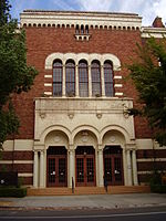
The Eastern Star Hall in Sacramento, California is a building from 1928. It was listed on the National Register of Historic Places in 1993.Sacramento's Eastern Star Hall was built in 1928 as a meeting hall for the Order of the Eastern Star, a Masonic women's organization. It is one of only four buildings constructed for the Eastern Star organization, and the only one still surviving and in active use. The building was listed in the National Register of Historic Places as a fine example of Romanesque Revival architecture, and a rare example of a local building devoted to a women's organization. The building was designed by the architectural firm of Coffman, Salsbury & Stafford in the Romanesque Revival style. An architect's drawing of the building includes five people in front of the building, all women. The women in the sketch were dressed in contemporary 1920s fashions, with bobbed hair and knee-length skirts, and one behind the wheel of an automobile. This sketch provides insight into the changing role of women in the 1920s, and reflects the intended purpose of the building as the home of a women's organization. The building was completed in 1928, and used for both public and private functions. Many local schools used the hall's grand ballroom for dances and social functions. A fire in December 1936 temporarily closed the hall, but it was quickly repaired and reopened. Located directly across from the reconstructed Sutter's Fort, the hall became one of many social institutions around the Fort's perimeter on the eastern end of K Street.

Alhambra Theatre (Sacramento)

The Alhambra Theatre opened in 1927 and was the preeminent movie house in the greater Sacramento area for many years. It was designed in the Moorish style of the great Spanish cities and included a large courtyard and fountain. The interior was lavishly appointed with red carpet, gold trim, and large pillars. It was located directly beyond the eastern terminus of K Street at 1025 Thirty-First Street, now Alhambra Boulevard, Sacramento, California 95816, in the East Sacramento neighborhood. The theatre was designed by Starks and Flanders, a firm which was founded in Sacramento by New Yorker Leonard Starks in 1922 and designed many other important structures, including the Fox-Senator Theatre, the Elks Building, C. K. McClatchy High School, and the downtown post office. The theatre was also home to the Alhambra Pipe Organ, an organ of fifteen ranks built by the Robert Morton Organ Company in 1927. After it was removed in 1960, the instrument was used by the First Baptist Church in Stockton and now resides with the Kautz family at Ironstone Vineyards.In 1973, a bond measure intended to allow the City of Sacramento to purchase the theatre failed to pass, and the Alhambra was demolished to make way for a Safeway supermarket. An original fountain is still intact and functioning on the south side of the Safeway parking lot. The destruction of the theatre, which was opposed by the public, awakened a preservation movement in Sacramento that remains active today and has adopted “Remember the Alhambra” as a slogan.