Ipbuk-dong
Neighbourhoods in Suwon

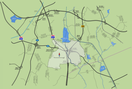
Ipbuk-dong is an administrative neighbourhood in Gwonseon-gu, Suwon, Gyeonggi-do, South Korea. Ipbuk-dong (입북동/笠北洞) is divided into two different legal-status neighbourhoods, namely Ipbuk-dong (same name) and Dangsu-dong (당수동/堂樹洞), which are separated by the Hwanggujicheon—a stream which flows south from Wangsong Reservoir on their northern boundary with the city of Uiwang, through Suwon, eventually to Asan Bay. Dangsu-dong has Suwon's sole boundary with Ansan, and meets Hwaseong further south. The neighbourhood is 96% green belt.
Excerpt from the Wikipedia article Ipbuk-dong (License: CC BY-SA 3.0, Authors, Images).Ipbuk-dong
Ipbuk-ro, Suwon-si
Geographical coordinates (GPS) Address Nearby Places Show on map
Geographical coordinates (GPS)
| Latitude | Longitude |
|---|---|
| N 37.293333333333 ° | E 126.95972222222 ° |
Address
입북동 행정복지센터
Ipbuk-ro 17
16367 Suwon-si
South Korea
Open on Google Maps


