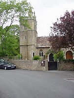
Churchill, Somerset

Churchill is a village and civil parish in the unitary authority of North Somerset, part of the ceremonial county of Somerset. It is located on the western edge of the Mendip Hills, about 8 miles (12.9 km) east of Weston-super-Mare, and about 15 miles (24.1 km) south-west of Bristol. The parish, which includes the village of Lower Langford and the hamlet of Upper Langford, has a population of 2,250.Although relatively close to large urban centres, Churchill has the character of a small country village. The village is settled around the junction of the A38 and A368 and is overlooked by Dolebury Warren, a biological Site of Special Scientific Interest (SSSI), Windmill Hill to the north, and the Mendip Hills, an Area of Outstanding Natural Beauty (AONB), to the south. Churchill, like many villages, grew around its medieval church, and has many listed buildings reflecting the history of the parish. There is one primary school, a secondary school, a post office, several shops and small businesses, three churches, and four pubs serving the area. There is also a doctor's surgery, allotments at Pudding Pie Lane, a hotel, and a number of bed and breakfast establishments. Recreation facilities include a sports centre with swimming pool, a dry ski slope and an outdoor pursuits. There are active cricket, football and skittles clubs, and many other leisure and sporting activities, including music and walking groups.
Excerpt from the Wikipedia article Churchill, Somerset (License: CC BY-SA 3.0, Authors, Images).Churchill, Somerset
Dinghurst Road,
Geographical coordinates (GPS) Address Nearby Places Show on map
Geographical coordinates (GPS)
| Latitude | Longitude |
|---|---|
| N 51.3354 ° | E -2.7963 ° |
Address
Dinghurst Road
Dinghurst Road
BS25 5PN
England, United Kingdom
Open on Google Maps


