Camp Hill, Birmingham

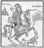
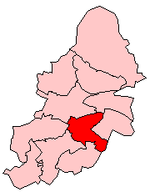
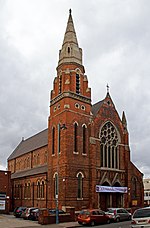
Camp Hill is the name of a road and surrounding area in Birmingham, West Midlands, England 1 mile (2 km) south east of the city centre.The area's name was first recorded as Kempe Hill, derived from a family name, in 1511, but it became known as Camp Hill after Prince Rupert set camp there in 1643, prior to the Battle of Camp Hill, during the English Civil War, reputedly using the Ship Inn as his headquarters.The area is dominated by a former Commissioners' Church, the Church of the Holy Trinity, designed by Francis Goodwin in decorated perpendicular gothic style and built from Bath stone in 1820–1822. Another notable local building is timber-framed Stratford House, built in 1601 and now a scheduled Ancient Monument and Grade II* Listed.The former King Edward VI Camp Hill Schools building is now a community centre; the schools relocated to Kings Heath in 1956. The grade II listed, Jacobean style, Lench's Trust almshouses on Ravenhurst Street are dated 1849 and were designed by J H Hornblower and Haylock.Dowding and Mills, a company specialising in motor rewinds was headquartered in Camp Hill for over 100 years from its foundation in 1913. Incorporated in 1919, the company was taken over by Swiss firm Sulzer in 2010 and the Camp Hill premises closed in 2021. Plans have been approved for the site to be cleared and replaced by the Camp Hill Gardens development of a 26 storey apartment tower, lower rise blocks and townhouses set around a private garden. The estimated completion date is 2024.
Excerpt from the Wikipedia article Camp Hill, Birmingham (License: CC BY-SA 3.0, Authors, Images).Camp Hill, Birmingham
Camp Hill Circus, Birmingham Digbeth
Geographical coordinates (GPS) Address Nearby Places Show on map
Geographical coordinates (GPS)
| Latitude | Longitude |
|---|---|
| N 52.468 ° | E -1.879 ° |
Address
Camp Hill Circus
Camp Hill Circus
B11 1AR Birmingham, Digbeth
England, United Kingdom
Open on Google Maps


