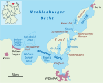
Breitling (Bay of Wismar)

The Breitling is a narrow strait in the Baltic Sea between the island of Poel and the mainland in the northeast of the district of Nordwestmecklenburg. It links the sheltered part of the Bay of Wismar, beginning south of Poeldamm, with the Salzhaff (into which estuaries of the Zaufe and Gollwitz empty). The Breitling is a very shallow body of water, mostly under one metre in depth. Large parts can even become exposed at low water, whereas at high water it can cover the low-lying causeway known as the Poeldamm. In the south the road link runs along a causeway (the Poeldamm) over a low peninsula to Poel over the Breitling. The waterbody is about five kilometres long and no more than one kilometre wide.
Excerpt from the Wikipedia article Breitling (Bay of Wismar) (License: CC BY-SA 3.0, Authors, Images).Breitling (Bay of Wismar)
Küstengewässer einschließlich Anteil am Festlandsockel
Geographical coordinates (GPS) Address Nearby Places Show on map
Geographical coordinates (GPS)
| Latitude | Longitude |
|---|---|
| N 53.983333333333 ° | E 11.483333333333 ° |
Address
Küstengewässer einschließlich Anteil am Festlandsockel
18569 Küstengewässer einschließlich Anteil am Festlandsockel
Mecklenburg-Vorpommern, Germany
Open on Google Maps


