place

John Pennekamp Coral Reef State Park

Aquaria in FloridaBeaches of Monroe County, FloridaCoral reefs of FloridaIUCN Category IVKey Largo
Landforms of Monroe County, FloridaNational Register of Historic Places in Monroe County, FloridaParks in Monroe County, FloridaParks on the National Register of Historic Places in FloridaProtected areas established in 1963State parks of FloridaTourist attractions in the Florida KeysUnderwater diving sites in the United StatesUse mdy dates from August 2023
Fish and corals in John Pennekamp Marine Park (2351507031)

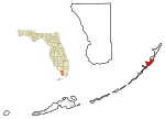
John Pennekamp Coral Reef State Park is a Florida State Park located on Key Largo in Florida. It includes approximately 70 nautical square miles (240 km²) of adjacent Atlantic Ocean waters. The park is approximately 25 miles in length and extends 3 miles into the Atlantic Ocean. It was the first underwater park in the United States. The park was added to the National Register of Historic Places on April 14, 1972. The primary attractions of the park are the coral reefs (such as Molasses Reef) and their associated marine life. In Fiscal Year 2004 the park had more than a million visitors, making it the most popular park in the Florida State Parks system. The Florida Keys and the Flower Garden Banks in the Gulf of Mexico off the Texas coast are the only living coral reef formations in the continental United States.

Excerpt from the Wikipedia article John Pennekamp Coral Reef State Park (License: CC BY-SA 3.0, Authors, Images).

John Pennekamp Coral Reef State Park
Mangrove Trail,

Geographical coordinates (GPS) Address Nearby Places
placeShow on map

Wikipedia: John Pennekamp Coral Reef State ParkContinue reading on Wikipedia

Geographical coordinates (GPS)

Latitude Longitude
N 25.12 ° E -80.405 °
placeShow on map

Address

Mangrove Trail

Mangrove Trail
33037
Florida, United States
mapOpen on Google Maps

Fish and corals in John Pennekamp Marine Park (2351507031)
Share experience

Nearby Places

Florida Reef
Florida Reef

The Florida Reef (also known as the Great Florida Reef, Florida reefs, Florida Reef Tract and Florida Keys Reef Tract) is the only living coral barrier reef in the continental United States. It lies a few miles seaward of the Florida Keys, is about 4 miles (6 to 7 km) wide and extends (along the 20 meter depth contour) 270 km (170 mi) from Fowey Rocks just east of Soldier Key to just south of the Marquesas Keys. The barrier reef tract forms a great arc, concentric with the Florida Keys, with the northern end, in Biscayne National Park, oriented north-south and the western end, south of the Marquesas Keys, oriented east-west. The rest of the reef outside Biscayne National Park lies within John Pennekamp Coral Reef State Park and the Florida Keys National Marine Sanctuary. Isolated coral patch reefs occur northward from Biscayne National Park as far north as Stuart, in Martin County. Coral reefs are also found in Dry Tortugas National Park west of the Marquesas Keys. There are more than 6,000 individual reefs in the system. The reefs are 5,000 to 7,000 years old, having developed since sea levels rose following the Wisconsinan glaciation.The densest and most spectacular reefs, along with the highest water clarity, are found to the seaward of Key Largo (in and beyond John Pennekamp Coral Reef State Park) and Elliott Key (the northernmost 'true' Florida Key) where the two long keys help protect the reefs from the effects of water exchange with Florida Bay, Biscayne Bay, Card Sound and Barnes Sound. The bays and sounds (all between the Florida Keys and the mainland) tend to have lower salinity, higher turbidity and wider temperature variations than the water in the open ocean. Channels between the Keys allow brackish water from the bays to flow onto the reefs (especially in the middle Keys), limiting their growth.

Caribbean Club

Caribbean Club on Key Largo, northernmost of the Florida Keys, was developed and built by auto parts and real estate promoter Carl Graham Fisher in 1938. Carl Fisher, considered a genius as a promoter, had conceived the Lincoln Highway, the first road across America, in 1913. Fisher had helped develop the Indianapolis Motor Speedway and Miami Beach and had at one time been worth an estimated $100 million. He lost his fortune in the Stock Market Crash of 1929 and the Great Depression. One source indicates that during the years before his death, Fisher was living in a modest cottage on Miami Beach.His last project was the development of the Caribbean Club on Key Largo as a fishing club for men who were far from wealthy. Eight years after his death, the Caribbean Club became famous as a purported "on location" filming site for the 1948 film Key Largo starring Humphrey Bogart and Lauren Bacall. In fact, only that film's initial exterior shots were filmed in the Florida Keys, and the rest was filmed in the Warner Bros. studio. After Fisher's death, the club was turned into a casino. In 1990, the Orlando Sentinel reviewed the sources of the rumours about the filming of "Key Largo" in an article titled "Who Cares if Bogie and Bacall Never Set Foot Here". At that time, the property was described as a motel with "modest rooms and cottages". By 1948, the property was owned by the Krone family in 1948; it was extensively damaged by fire in 1955 and it was rebuilt in a different style. The Caribbean Club was acquired by Ruth and Lefty Whitehurst in 1963; fire again caused damage in 1971 and repairs were completed. As of 2021, the business was operated by the couple's children and grandchildren. The family's website was reporting that exterior shots for "Key Largo" were filmed here.

Key Largo
Key Largo

Key Largo (Spanish: Cayo Largo) is an island in the upper Florida Keys archipelago and is the largest section of the keys, at 33 miles (53 km) long. It is one of the northernmost of the Florida Keys in Monroe County, and the northernmost of the keys connected by U.S. Highway 1 (the Overseas Highway). Three census-designated places are on the island of Key Largo: North Key Largo, near the Card Sound Bridge, Key Largo, eight to nine miles from the southern end of the island, and Tavernier, at the southern end of the island. As of 2010, the three places have a combined population of 13,850. None of Key Largo is an incorporated municipality, so it is governed at the local level by Monroe County. Key Largo is connected to the mainland in Miami-Dade County by two routes. The first route is the Overseas Highway, the southernmost portion of U.S. Highway 1, which enters Key Largo at Jewfish Creek near the middle of the island and turns southwest. The second route is Card Sound Road, which connects to the northern part of Key Largo at Card Sound Bridge and runs southeastward to connect with County Road 905, which runs southwest and joins U.S. 1 at about mile marker 106. These routes originate at Florida City on the mainland. Key Largo is a popular tourist destination and calls itself the "Diving Capital of the World" because the living coral reef a few miles offshore attracts thousands of scuba divers and sport-fishing enthusiasts.Key Largo's proximity to the Everglades also makes it a premier destination for kayakers and ecotourists. Automotive and highway pioneer and Miami Beach developer Carl G. Fisher built the Caribbean Club in 1938 as his last project. Key Largo is situated between Everglades National Park to the northwest and John Pennekamp Coral Reef State Park to the east, the first underwater park in the United States, which protects part of the Florida Reef, the only living coral barrier reef in the continental United States.