place

St Mary Hoo

Civil parishes in KentMedwayPopulated places on the River ThamesVillages in Kent
StMaryHoo3097c
StMaryHoo3097c

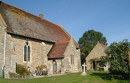
St Mary Hoo is a village and civil parish in Kent, England. It is on the Hoo Peninsula in the borough of Medway. According to the 2001 census it had a population of 244, falling to 238 at the 2011 Census.The first appearance of the name is in 1240. St Mary's Church at St Mary Hoo was the parish church and gave its name to the village, and although it remains a Grade II building, dating from the 14th century, it has been reconstructed as a private house. Formally rebuilt in about 1881 of local ragstone, it has an unrestored 15th century southwest window that is noteworthy. Newlands Farmhouse nearby along the ridge track to Northward Hill is a Grade II farmhouse which was built in 1746. The Old Rectory at St Mary Hoo is a Grade II house built in the late 18th century. It has a special place in scandals involving the royalty. The rectors from 1788 to 1875 were a father and son, both named R. Burt. The senior of the two, the Rev. Robert Burt, one of the prince's Chaplains in Ordinary, whose debts (of £500) were paid by the prince to release him from the Fleet Prison, performed the illegal marriage ceremony between Prince George (afterwards King George IV) and Mrs Fitzherbert in 1785. A plaque commemorating this event remains hidden in the old church of St Mary. St Mary's Hall, also at St Mary Hoo, was built in the 17th century and added to in 1830. It was the home of the Victorian farm innovator Henry Pye between 1845 and 1909. Fenn Farm House was built in the 15th century. In 1760 it was re-faced during the reign of George II. It was listed as a Grade 2 historic building in 2001.

Excerpt from the Wikipedia article St Mary Hoo (License: CC BY-SA 3.0, Authors, Images).

St Mary Hoo
Ratcliffe Highway,

Geographical coordinates (GPS) Address Nearby Places
placeShow on map

Wikipedia: St Mary HooContinue reading on Wikipedia

Geographical coordinates (GPS)

Latitude Longitude
N 51.459 ° E 0.6 °
placeShow on map

Address

Ratcliffe Highway

Ratcliffe Highway
ME3 8RB , St. Mary Hoo
England, United Kingdom
mapOpen on Google Maps

StMaryHoo3097c
StMaryHoo3097c
Share experience

Nearby Places

South Thames Estuary and Marshes

South Thames Estuary and Marshes is a 5,289-hectare (13,070-acre) biological Site of Special Scientific Interest which stretches between Gravesend and the mouth of the River Medway in Kent. Part of it is a Nature Conservation Review site, Grade I, and part is a Royal Society for the Protection of Birds nature reserve. It is part of the Thames Estuary and Marshes Ramsar internationally important wetland site and Special Protection Area under the European Union Directive on the Conservation of Wild Birds.The site consists of a range of habitats including mudflats, saltmarsh, grazing marsh and stretches of shingle. Inland are freshwater lagoons and some patches of deciduous woodland. Over 20,000 migratory waterfowl use this site in the winter, and some species such as greater white-fronted goose, shelduck, gadwall, teal, northern pintail, shoveler, grey plover, curlew and black-tailed godwit are present in internationally important numbers. There are also a number of breeding birds including garganey, avocet, northern pintail, bearded reedling, hen harrier, short-eared owl, ruff, common tern and European golden plover. There are nationally scarce plants on dykes and the drier parts of the site, and the saltmarsh is dominated by salt grasses, the glassworts Salicornia, sea aster, sea lavender and sea purslane. Also present are the nationally scarce plants golden samphire and Puccinellia fasciculata. The diverse invertebrates include nationally rare beetles, flies and true bugs; the scarce emerald damselfly and eight species of water beetle, including the great silver water beetle, are found here.

Stoke, Kent
Stoke, Kent

Stoke is a civil parish on the Hoo Peninsula in Kent, England, to the south of Allhallows, on the north of the Medway Estuary. The parish had a population of 1,060 at the 2011 census.The two small villages of Lower Stoke and Stoke (sometimes referred to as Upper Stoke) stand on low-lying fertile farmland that is at most 17 m above highwater. The farmland descends to the Stoke Saltings – a maze of intricate channels and small islands beloved by wading birds. The church of Saints Peter and Paul is in Stoke; it was an appendage to the Manor of Great Hoo. The building contains some Norman and Early English work dating from 1175. It has no spire.In an Anglo-Saxon charter Stoke is referred to as "Andescohesham". It was passed with other lands by Eadberht, son of King Wihtred of Kent to the See of Rochester for "the good of his soul and the remission of sins". In 959, Lower Stoke, then called "Osterland", was granted by Queen Eadgifu to Christ Church, Canterbury. In Domesday Book it is called "Estoches" and "Stoches".Due to its low-lying nature, Stoke has often suffered flooding, such as in 1158, 1235, 1309, 1682, and 1735 when ploughmen were swept from their fields as the sea broke through. Also, in 1791, 1854, 1874, and 1897, Stoke was cut off from the Isle of Grain for a week.In 1720 Manor Farm was leased to Jacob Sawbridge, one of the South Sea Bubble directors.In 1732 William Hogarth stayed overnight at the 'Nag's Head' in Lower Stoke. Due to the shortage of beds he had to share a bed.There was a large airship base nearby at Kingsnorth from which patrols covering the North Sea were launched during World War I. The site is now covered by Kingsnorth Power Station. Stoke has a private unlicensed airfield, home to Medway airsports club and previously part of Medway Microlights manufacturing microlight aircraft such as the Medway Executive SLA. Stoke Medway airfield is known in the aviation community as being a particularly challenging airfield to fly from. It is unique in its topography as it is situated parallel to marshes of the river Medway on one side of the runway. On the other side of the runway is an active rail line and high tension electricity pylons. The runway also has a curve along its entire length and is relatively short in aviation terms of only bring approx 450 metres long.

High Halstow NNR
High Halstow NNR

High Halstow National Nature Reserve is on the Hoo Peninsula north of Chatham. It is also part of the Northwood Hill Royal Society for the Protection of Birds Reserve (which is 270 hectares of grazing marsh, woodland and farmland). It was declared a National Nature Reserve in 1951.The reserve and the woodland lies on the hill to the north of the village of High Halstow. The woodland, is situated on London Clay, comprises large oak trees and hawthorn scrub, with several sycamore trees. English elm was formerly abundant but has largely been killed by Dutch elm disease. The woodland has a diverse flora with over 200 plants recorded, including trees and shrubs. It is also noted for its diversity of butterflies. A number of rare moths have been recorded at the site. The sloe carpet (Aleucis distinctata), least carpet (Idaea vulpinaria) and a colony of the white-letter hairstreak butterfly have been noted on the reserve. Also nine species of dragonfly have also been recorded in the reserve. The reserve is also home to a flock of nightingales. Also the UK's largest and most famous colonies of little egrets, they have been nesting at the site since 2000, reaching approximately 93 pairs by 2007. The reserve may be visited either from (grid ref TR220606) the carpark off Northwood Avenue, to the South-of the woodland. Or from Buckland Farm (the RSPCA Farm and carpark), to west of the woodland. The reserve has a nature trail with attractive sea views and long distance views of the River Medway. The Saxon Shore Way long distance path passes through the reserve between Cooling and High Halstow.