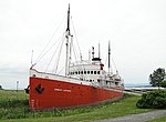
HMCS Bras d'Or (FHE 400)

HMCS Bras d'Or (FHE 400) was a hydrofoil that served in the Canadian Forces from 1968 to 1971. During sea trials in 1969, the vessel exceeded 63 knots (117 km/h; 72 mph), making her the fastest unarmed warship in the world at the time. The vessel was originally built from 1960 to 1967 for the Royal Canadian Navy, as a project for the testing of anti-submarine warfare technology on an ocean-going hydrofoil. The RCN was replaced on 1 February 1968 by the unified Canadian Armed Forces, and Bras d'Or was commissioned into that service several months later. Changes in priorities and cost overruns later led to the project's cancellation. Bras d'Or was named in honour of Bras d'Or Lake on Nova Scotia's Cape Breton Island, where inventor Alexander Graham Bell performed hydrofoil experiments in the early 20th century near his estate and new laboratory at Beinn Bhreagh, setting the world watercraft speed record in the process. In 1909 the lake was also the historic site of the first flight of an aircraft in Canada and the British Commonwealth; the airplane, named the Silver Dart, was built by the Aerial Experiment Association under Dr. Bell's tutelage. The lake's name was thus fitting for a hydrofoil vessel which could 'fly' above an ocean's surface.
Excerpt from the Wikipedia article HMCS Bras d'Or (FHE 400) (License: CC BY-SA 3.0, Authors, Images).HMCS Bras d'Or (FHE 400)
Chemin des Pionniers Est,
Geographical coordinates (GPS) Address External links Nearby Places Show on map
 Continue reading on Wikipedia
 Geographical coordinates (GPS)
| Latitude | Longitude |
|---|---|
| N 47.12943 ° | E -70.37209 ° |
Address
HMCS Bras d'Or (FHE 400)
Chemin des Pionniers Est
G0R 2B0
Quebec, Canada
Open on Google Maps
External links