Bootle Oriel Road railway station
BootleFormer Lancashire and Yorkshire Railway stationsPages with no open date in Infobox stationRailway stations in Great Britain opened in 1850Railway stations in the Metropolitan Borough of Sefton ... and 2 more
Railway stations served by MerseyrailUse British English from December 2016

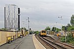
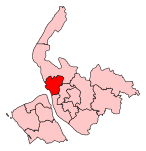
Bootle Oriel Road railway station is a railway station in Bootle, Merseyside, England. It is situated near the town's Victorian civic centre, opposite Bootle Town Hall, although the surrounding area is now largely residential. It is located on the Northern Line of the Merseyrail network.
Excerpt from the Wikipedia article Bootle Oriel Road railway station (License: CC BY-SA 3.0, Authors, Images).Bootle Oriel Road railway station
Oriel Road,
Geographical coordinates (GPS) Address External links Nearby Places Show on map
Geographical coordinates (GPS)
| Latitude | Longitude |
|---|---|
| N 53.4468 ° | E -2.9957 ° |
Address
Bootle Oriel Road
Oriel Road
L20 7EP
England, United Kingdom
Open on Google Maps


