place

Eglisau railway station

Pages with no open date in Infobox stationRailway stations in the canton of ZürichSwiss Federal Railways stationsSwiss railway station stubs
StatioEglisauV
StatioEglisauV

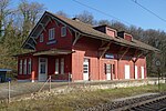
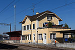
Eglisau railway station (German: Bahnhof Eglisau) is a railway station in the Swiss canton of Zurich and municipality of Eglisau. The station is located on the Winterthur to Koblenz line, at that line's junction with the Eglisau to Neuhausen line. Both lines are owned by Swiss Federal Railways. It is served by Zürich S-Bahn lines S9, between Zürich and Schaffhausen, and S36, between Bülach and Koblenz.The railway crosses the Eglisau railway bridge over the Rhine, between Eglisau and the next station, Hüntwangen-Wil on the Eglisau to Neuhausen line.

Excerpt from the Wikipedia article Eglisau railway station (License: CC BY-SA 3.0, Authors, Images).

Eglisau railway station
Bahnhofstrasse,

Geographical coordinates (GPS) Address Nearby Places
placeShow on map

Wikipedia: Eglisau railway stationContinue reading on Wikipedia

Geographical coordinates (GPS)

Latitude Longitude
N 47.572388888889 ° E 8.5166111111111 °
placeShow on map

Address

Bahnhofstrasse 11
8193
Zurich, Switzerland
mapOpen on Google Maps

StatioEglisauV
StatioEglisauV
Share experience

Nearby Places

Töss (river)
Töss (river)

The Töss is a river of the canton of Zürich. It starts with the confluence of the Vordertöss and the Hindertöss in the Zürcher Oberland, at Tössscheidi on 796 metres (2,612 ft) on the border between the municipalities of Wald west of the Dägelschberg (1,267 m (4,157 ft)), east of the Hüttchopf (1,231 m (4,039 ft)), and north of the Tössstock (1,153 m (3,783 ft))). The Vordertöss (lit.: 'Front Töss') rises on the south side of the Tössstock on the north faces of the Schwarzeberg (1,293 m (4,242 ft)) and Höchhand (1,314 m (4,311 ft)) before it circumvent the Tössstock on its western flank. The larger tributary, the Hindertöss (lit.: 'Back Töss') collects the waters, either, by its tributary, the Chreuelbach, below the Höchhand, the western faces of the Habrütispitz (1,274 m (4,180 ft)) and Rossegg (1,254 m (4,114 ft)), or, from its own sources below Schindelegg (1,265 m (4,150 ft)), and the south faces of Schindelberghöchi (1,234 m (4,049 ft)) and the Dägelschberg, and passes the Tössstock on its northern hillside. The Töss flows to the north before it meets the main valley of its own name, Töss Valley (Tösstal) just before Steg im Tösstal. Here, the river and its valley turns to the west in order to flow through Bauma then turns to the north again. West of the village Turbenthal it turns west again, and the valley gets even more ragged than before. It traverses Winterthur on its most western part of the city, just northeast of the Töss, a city mountain. After joining the Eulach on the western exit of the city, the river Töss then continues more or less westnorthwestern and joins the Rhine after about 11 kilometres (6.8 mi) on Rhine's large southern bend called Tössegg west of Teufen and just before Eglisau.

Glatt (Rhine)
Glatt (Rhine)

Glatt (German pronunciation: [ˈɡlat]) is the name of a lesser affluent to the High Rhine in the Unterland of the canton of Zurich, Switzerland. It is 35.7 kilometres (22.2 mi) long and flows out from the Greifensee through the Glatt Valley, discharging into the Rhine by Glattfelden. Whereas the upper reaches are only gently inclined, the stream gets steeper beneath, forming banks of bed load. The earliest mention of the Glatt (fluvii, qui dicitur glat) dates to 1034. The hydronym reflects the (feminine) OHG adjective glat, meaning either "bright, clear" or "plane, smooth". Since the 15th century, the Glatt had been subject to the sovereignty of the city of Zurich, the council of which assigned the custody over the river to two reeves (Glattvögte) in the 16th century. After a first attempt to regulate the stream in 1593 and a rudimentary project in the early 19th century, the largest reshapings took place during the time from 1878 to 1895. In 1936, another straightening was carried out as a preliminary work to the construction of the Zurich Airport as well as to land improvement and future overbuilding. Due to the last regulation works in 1975 between Niederglatt and the Glatt's confluence to the Rhine, the hydroelectric power stations built in the late 19th century at the lower course of the stream disappeared. The Glatt was formerly abounding with fish. Owing to the accelerated growth of Zurich's agglomeration during the 20th century and the insufficiency of the purification plants built in the 1960s, it has been strongly polluted; from 1994 to 2002, the sewage system was restructured by driving a tunnel between the Glatt Valley and the Limmat Valley.