place

Marchlyn Mawr

Gwynedd geography stubsLlanddeiniolenReservoirs in GwyneddReservoirs in Snowdonia
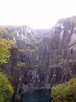
Marchlyn Mawr from Elidir Fawr geograph.org.uk 8192

Marchlyn Mawr reservoir is a high level lake in Snowdonia behind Elidir Fawr mountain. It is used as the high level water source for Dinorwig power station, a closed-loop pumped storage hydroelectric generating facility. It is said that nearby lies the cave containing Arthur's treasure, a source of bedazzlement to the wanderer who sees it, and of disaster to the pilferer who touches it. The lake itself lies in between two mountains Carnedd y Fillast and Elidir Fawr and lies at a height of 636m above sea level and the reservoir took four years to build (from 1975 to 1979). The reservoir holds about 9.2 million cubic metres (320 million cubic feet) of water. From the reservoir, a 10.5-metre (34 ft) diameter tunnel runs for 1.7 km (1.1 miles) to a 10 m (33 ft) diameter vertical shaft. From the bottom of the shaft, a 9.45 m (31 ft) diameter tunnel leads to the power station, 670 metres (2,200 ft) away. It is possible to cycle up the road to the reservoir but a gate at the bottom prevents cars from driving on the road.

Excerpt from the Wikipedia article Marchlyn Mawr (License: CC BY-SA 3.0, Authors, Images).

Geographical coordinates (GPS)

Latitude Longitude
N 53.136666666667 ° E -4.0691666666667 °
placeShow on map

Address


LL55 3NA , Llanddeiniolen
Wales, United Kingdom
mapOpen on Google Maps

Marchlyn Mawr from Elidir Fawr geograph.org.uk 8192
Share experience

Nearby Places

Mynydd Llandygai
Mynydd Llandygai

Mynydd Llandygái (also spelt Mynydd Llandegai, [ˌmənɨðˌɬandəˈɡai] ; from Welsh mynydd "mountain", Llandygai "Church of St Tegai") is a small, partly forested hill in Gwynedd, North Wales. It forms the start of the Glyderau ridge. It is also the name of the quarry village at the base of the hill situated at the edge of Snowdonia National Park at grid reference SH600656. The village lies at about 1,000 feet (300 m) above sea level and gets strong winds and above average rainfall. Many of the houses are spread along long roads rather than clustered around a point, giving the village a somewhat decentralised feel. However the village is distinguished by two parallel rows of semi-detached quarrymen's cottages constructed during the 19th century for workers of Penrhyn Quarry, which mined slate. The first mention of housing on the site can be found in the census of 1841. Each of the houses was provided with an area of land (approximately 1 acre) sufficient to feed the family. This arrangement is clearly visible on the map of the area. This can be contrasted with the situation in the South Wales coalfields or in the industrial Midlands where no such provision was made for the workers. Originally named Douglas Hill, the name was changed in the 1930s after the inhabitants decided that they did not want to associate with the name Douglas, namely part of the Penrhyn family surname. (See Baron Penrhyn.) Physically the village has changed little since it was originally built. The area to the south is mountainous and there are a number of slate and stone quarries in the vicinity.

Llyn Peris
Llyn Peris

Llyn Peris is a lake in Snowdonia, Wales, approximately 1.8 km long and situated close to the villages of Llanberis and Nant Peris, and the smaller twin of Llyn Padarn. The lake was formed glacially and is an example of a moraine-dammed lake. Llyn Peris is named after Saint Peris, an early Christian saint of whom little is known. The lake is flanked on one side by the mountain Elidir Fawr and the former slate quarry of Dinorwig. Above the opposite bank are the hills of Derlwyn and Clogwyn Mawr and a rock formation known as the Lady of Snowdon, due to its resemblance to a human face. The ruins of Dolbadarn Castle are also located on a mound above the lake. The lake now forms the lower reservoir of Dinorwig power station, and the administrative buildings for the station are situated on the lake shore. Water is released into the lake from Marchlyn Mawr (the upper reservoir) to produce electricity during periods of peak demand. This water is, in turn, pumped back to the upper reservoir using electricity purchased at off-peak periods. The water level of the lake therefore varies considerably, depending on UK electricity demand. Excess water from the lake drains into Llyn Padarn. During construction of the power station, when the capacity of the lake was increased considerably at this time, with the removal of a large quantity of slate waste, rare Welsh Arctic char fish were removed to four other lakes in the neighbouring Carneddau mountains, namely Ffynnon Llugwy, Llyn Cowlyd, Llyn Melynllyn and Llyn Dulyn, where they are still to be found. Although Llyn Peris itself was not restocked, some char have found their way back to the lake. Parts of the lake shore are designated as a Site of Special Scientific Interest for Glacial Geology.