Hesbaye
Areas of BelgiumGeographic history of BelgiumLandforms of FlandersLandforms of Flemish BrabantLandforms of Limburg (Belgium) ... and 8 more
Landforms of Liège ProvinceLandforms of WalloniaLandforms of Walloon BrabantNatural regions of BelgiumPages with Dutch IPAPages with French IPARegions of FlandersRegions of Wallonia

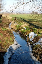
The Hesbaye (French, French pronunciation: [ɛsbɛ]), or Haspengouw (Dutch and Limburgish, Dutch pronunciation: [ˈɦɑspə(ŋ)ˌɣʌu]), is a traditional cultural and geophysical region in eastern Belgium. It is a loamy plateau region which forms a watershed between the Meuse and Scheldt drainage basins. It has been one of the main agricultural regions in what is now Belgium since before Roman times, and specifically named in records since the Middle Ages, when it was an important Frankish pagus or gau, called Hasbania in medieval Latin.
Excerpt from the Wikipedia article Hesbaye (License: CC BY-SA 3.0, Authors, Images).Hesbaye
Nieuwe Steenweg,
Geographical coordinates (GPS) Address Nearby Places Show on map
Geographical coordinates (GPS)
| Latitude | Longitude |
|---|---|
| N 50.75 ° | E 5.3 ° |
Address
Nieuwe Steenweg 7
3870 (Heers)
Limburg, Belgium
Open on Google Maps


