place

Strafforth and Tickhill

South Yorkshire geography stubsTickhillUse British English from October 2022Wapentakes of the West Riding of Yorkshire
Wapentakes of the West Riding of Yorkshire

Strafforth and Tickhill , originally known as Strafforth, was the southernmost wapentake in the West Riding of Yorkshire, England. The west of the district, plus a detached area in the east, constituted the Upper Division, while the central area and a detached part in the extreme east constituted the Lower Division. Parishes in the Upper Division included Aston, Barnby Dun, Braithwell, Conisbrough, Dinnington, Ecclesfield, Firbeck, Handsworth, Harthill, Hatfield, Hooton Roberts, Laughton-en-le-Morthen, Maltby, Ravenfield, Rawmarsh, Rotherham, Sheffield, Slade Hooton, South Anston, Sprotborough, Stone, Thorpe Salvin, Thrybergh, Todwick, Treeton, Wales, Wath-upon-Dearne, Whiston, Wickersley and parts of Finningley. The Lower Division included the parishes of Adwick-le-Street, Adwick-upon-Dearne, Arksey, Armthorpe, Bolton-upon-Dearne, Brodsworth, Darfield, Doncaster, Fishlake, High Melton, Hooton Pagnell, Kirk Sandall, Mexborough, Rossington, Thorne, Thurnscoe, Tickhill, Wadworth, Warmsworth, parts of Blyth, Nottinghamshire and the extra-parochial area of Hampole. The original meeting place of the wapentake is unknown, but may have been the future site of Conisbrough Castle.The Earldom of Strafford takes its name from a variant of this district name, wherein the first incumbent Thomas Wentworth, 1st Earl of Strafford originated.

Excerpt from the Wikipedia article Strafforth and Tickhill (License: CC BY-SA 3.0, Authors, Images).

Strafforth and Tickhill
Castle Gate, Doncaster Tickhill

Geographical coordinates (GPS) Address Nearby Places
placeShow on map

Wikipedia: Strafforth and TickhillContinue reading on Wikipedia

Geographical coordinates (GPS)

Latitude Longitude
N 53.432 ° E -1.109 °
placeShow on map

Address

Castle Gate

Castle Gate
DN11 9QP Doncaster, Tickhill
England, United Kingdom
mapOpen on Google Maps

Wapentakes of the West Riding of Yorkshire
Share experience

Nearby Places

St Leonard's Hospital, Tickhill

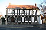
St Leonard's Hospital is a grade II* listed timber-framed building in Tickhill, South Yorkshire, in England. It was originally constructed in the 15th century as a monastic building. The first hospital in Tickhill dedicated to Saint Leonard was on Spital Hill, a marshy location outside the built-up part of the town, considered suitable as accommodation for lepers. It was already in existence by 1225, when Walter de Gray, Archbishop of York, deplored the decayed condition of the friars attending and called for charitable donations. The lepers were first mentioned in 1236, while from 1290, John Clarel attempted to improve conditions at the hospital. There has been scholarly debate as to whether this is the same foundation as that of St Thomas in the marsh, a cell of Humberston Abbey.In 1470, the hospital was relocated to the north side of Tickhill Market Place. An inscription above the door suggests that the rebuilding was the work of a John Leftwul. The reasons for the move are unknown, but David Hey notes that this must have involved a change in purpose, as town centres were not considered suitable locations for lepers. The building eventually declined; by the 1840s, it was used as tenements, but the facade was substantially intact. It was heavily restored in 1851, with the upper floor being completely rebuilt in a Gothic revival style. In 1898, it was purchased by the local parish church, who turned it into a parish meeting room. It was again restored in 2007.As it stands, the hospital has ten bays separated by wooden posts, carrying half-fan vaulting supporting an oversailing upper storey. The top floor has three distinctive windows with straight sides but pointed heads. It was made a listed building in 1961 and is currently listed at grade II*.