Sackwald
Forests and woodlands of Lower SaxonyHildesheim (district)Hill ranges of Lower SaxonyNatural regions of the Weser-Leine Uplands

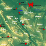
The Sackwald is a ridge, up to 374 m above sea level (NN) high, in the Lower Saxon Hills in the district of Hildesheim in the North German state of Lower Saxony. It is named after the village of Sack in the borough of Alfeld, the name meaning "Sack Forest". The Sackwald is part of the geological structure of the Sack Basin or Sackmulde along with the Sieben Berge and the Vorberge.
Excerpt from the Wikipedia article Sackwald (License: CC BY-SA 3.0, Authors, Images).Sackwald
Am Bornacker,
Geographical coordinates (GPS) Address Nearby Places Show on map
Geographical coordinates (GPS)
| Latitude | Longitude |
|---|---|
| N 51.9666667 ° | E 9.9166667 ° |
Address
Am Bornacker
31084
Lower Saxony, Germany
Open on Google Maps


