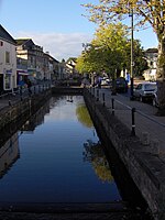
Westfield, Somerset

Westfield is a settlement lying on the Fosse Way between Radstock and Midsomer Norton in Somerset, England. In 2011 it was raised to the status of a civil parish. It is 10.5 miles (16.9 km) south-west of Bath, 12 miles (19 km) north-east of Wells, 12 miles (19 km) west of Trowbridge, 9 miles (14 km) north-west of Frome, and 17 miles (27 km) south-east of Bristol. Its geographical location on the A367 south of Bath has resulted in it being an important base for services for the population centres of the old Somerset Coalfield area, for which it hosts the police and fire stations and the local further education college. For many years it hosted the annual winter carnival, until in 2014 the carnival route was changed.
Excerpt from the Wikipedia article Westfield, Somerset (License: CC BY-SA 3.0, Authors, Images).Westfield, Somerset
Church Street,
Geographical coordinates (GPS) Address Nearby Places Show on map
Geographical coordinates (GPS)
| Latitude | Longitude |
|---|---|
| N 51.29 ° | E -2.448 ° |
Address
Church Street
BA3 3QG , Northfield
England, United Kingdom
Open on Google Maps


