place

Bonmont Abbey

1110s establishments in Europe12th-century establishments in SwitzerlandBuildings and structures in the canton of VaudChristian monasteries established in the 12th centuryCistercian monasteries in Switzerland
Cultural property of national significance in the canton of VaudMonasteries dissolved under the Swiss Reformation
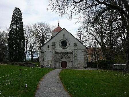
Abbaye de Bonmont 3
Abbaye de Bonmont 3

Bonmont Abbey (French: Abbaye de Bonmont) is a former Cistercian monastery in the municipality of Chéserex in the canton of Vaud in Switzerland. It is a Swiss heritage site of national significance.

Excerpt from the Wikipedia article Bonmont Abbey (License: CC BY-SA 3.0, Authors, Images).

Bonmont Abbey
Route de Bonmont,

Geographical coordinates (GPS) Address External links Nearby Places
placeShow on map

Wikipedia: Bonmont AbbeyContinue reading on Wikipedia

Geographical coordinates (GPS)

Latitude Longitude
N 46.402777777778 ° E 6.1491666666667 °
placeShow on map

Address

Abbaye de Bonmont

Route de Bonmont
1275
Vaud, Switzerland
mapOpen on Google Maps

linkWikiData (Q681172)
linkOpenStreetMap (159412133)

Abbaye de Bonmont 3
Abbaye de Bonmont 3
Share experience

Nearby Places

Divonne-les-Bains
Divonne-les-Bains

Divonne-les-Bains (French pronunciation: [di'vɔn le 'bɛ̃]; Arpitan: Digouona), popularly known as Divonne, is a commune in the Ain department in the Auvergne-Rhône-Alpes region in Eastern France. Divonne-les-Bains is a spa town situated on the border with French-speaking Switzerland, between the foot of the Jura Mountains and Lake Geneva. It is situated in the Pays de Gex, about 8 km (5.0 mi) from Gex to the southwest, from which the area takes its name. Divonne-les-Bains is about 20 km (12 mi) from Geneva to the south and 10 km (6.2 mi) from Nyon to the northeast. Since 2012, Divonne-les-Bains has formed part of a wider agglomeration known as the Grand Genève (Greater Geneva). A short way above the town are several springs, which were exploited in the 19th century to provide spa facilities for which Divonne-les-Bains became renowned. The golf course was built in the 1930s. Many of its present-day amenities (casino, hippodrome, open air swimming pool, as well as the Lac de Divonne, an artificial lake) were built after 1945. The Casino de Divonne was opened in 1954. A cultural centre by the lake (L'Esplanade du Lac) was completed in 2005. Divonne-les-Bains used to host a small chamber music festival every summer, centred on its tiny theatre and the Domaine de Divonne. The Château of Divonne, now a luxury hotel, suffered a serious fire in January 2017; it is currently being rebuilt. There is a lively market on Sundays and a succession of cultural and sporting events throughout the year. Every year, the town hosts a folk festival in the beginning of July at the hippodrome called Les Vaches Folks.

La Dôle
La Dôle

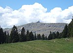
La Dôle is a mountain of the Jura, overlooking Lake Geneva in the westernmost part of the canton of Vaud. Rising to an altitude of 1677 meters, it is the second highest peak in the Swiss portion of the Jura, after Mont Tendre. Administratively, the summit is split between the municipalities of Gingins, Chéserex and La Rippe. The mountain is also close to and easily accessible from Saint-Cergue and the Col de la Givrine to the north, both above 1000 meters and connected to Nyon on Lake Geneva by road and by the Nyon–St-Cergue–Morez Railway. A paved road also climbs to the Chalet de la Dôle below the summit (1439 m) from Gingins.La Dôle overlooks to south-east the summit of La Barillette, the town of Nyon, Lake Geneva and across the lake the Alps, including the Bernese Alps the Chablais Alps and the Mont Blanc massif. To the south are views of the City of Geneva and the Canton of Geneva; to the north the village of Les Rousses. The Dôle massif has a second peak to the northeast, the Pointe de Poêle Chaud, accessible via the col between them which drops to 1557 m. La Dôle massif is the northwesternmost part of the Swiss Plateau. To the southwest it ends at the Col de la Faucille, and to the northwest at the Valserine valley, a Rhône tributary. To the north it ends at the Col de la Givrine, and towards the southeast merges into the Swiss Plateau. The northwestern side of La Dôle is equipped with ski-lifts and is traversed by alpine ski paths. There is a restricted-access cable car which provides service to the various electronic facilities on the top, including a ball containing aviation radar, a Swiss weather station, television, radio and EBU telecommunications.