place

Parvin Bridge

1921 establishments in OregonCovered bridges in Lane County, OregonCovered bridges on the National Register of Historic Places in OregonHowe truss bridges in the United StatesNational Register of Historic Places in Lane County, Oregon
Road bridges on the National Register of Historic Places in OregonWooden bridges in Oregon
Parvin Covered Bridge (Dexter, Oregon) 1921

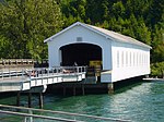
The Parvin Bridge is a covered bridge located in Lane County, Oregon, U.S. near Dexter. It was built in 1921 as a single-lane 75-foot (23 m) bridge across Lost Creek, a tributary of the Middle Fork Willamette River. The bridge was a replacement for a 66-foot (20 m) Howe truss design which failed a 1917 inspection by bridge inspector J. W. McArthur. He wrote, "An old bridge. Chords badly worm eaten. Downstream chord has been reinforced in middle by a timber bolted on. Wood is but little better than a powder from worm action. All signs indicate a new bridge in from 2 to 4 years."George W. Breeding constructed the present bridge at the same site in 1921 for $3,617, equivalent to $59,300 today. It is also a Howe truss and includes a 62-foot (19 m) eastern approach and a 17-foot (5.2 m) western approach. Roadwork in the mid-1970s realigned the road to bypass the bridge, being accessible only to pedestrians afterwards. A dedication ceremony was held November 17, 1986, to reopen the renovated span to vehicle traffic with a 10-short-ton (9,100 kg) load limit.The Parvin Bridge is listed on the National Register of Historic Places.

Excerpt from the Wikipedia article Parvin Bridge (License: CC BY-SA 3.0, Authors, Images).

Parvin Bridge
Parvin Road,

Geographical coordinates (GPS) Address Nearby Places
placeShow on map

Wikipedia: Parvin BridgeContinue reading on Wikipedia

Geographical coordinates (GPS)

Latitude Longitude
N 43.899722222222 ° E -122.82138888889 °
placeShow on map

Address

Parvin Road 82229
97431
Oregon, United States
mapOpen on Google Maps

Parvin Covered Bridge (Dexter, Oregon) 1921
Share experience

Nearby Places

Elijah Bristow State Park

Elijah Bristow State Park is a state park in the U.S. state of Oregon, administered by the Oregon Parks and Recreation Department. It has more than 10 miles (16 km) of well-maintained trails along ponds, wetlands, meadows, and the Middle Fork Willamette River, and through forests of broadleaf and evergreen trees. The trails are open to horses, hikers, and mountain bikers, and there is a separate equestrian staging area popular with riding clubs.The 847-acre (343 ha) park was named for Elijah Bristow, one of the first pioneer settlers in Lane County. Located directly downstream of Dexter Reservoir, the site was originally called Dexter State Park. It was renamed in 1979 to honor Bristow, who founded the nearby community of Pleasant Hill in the mid-19th century.The park's trail system includes part of a trail linking Alton Baker Park in Eugene to the Pacific Crest Trail near Oakridge. Named trails in the park include Equestrian, River, Lost Creek, Pond Loop, and Fishermen's, which interconnect "like a tangle of intersecting puzzle pieces".Wildlife in the park includes salmon and steelhead, osprey, great blue herons, bald eagles and beaver. Among the thousands of species in the park are the threatened Western pond turtle and the Oregon chub.Activities, in addition to hiking, horse riding, biking, and fishing, include wildlife watching, picnicking, and boating. A wildlife viewing platform overlooks the pond complex in the park.