place

Duquesne Incline

1877 establishments in Pennsylvania5 ft gauge railways in the United StatesCableways on the National Register of Historic PlacesFunicular railways in the United StatesHistoric Mechanical Engineering Landmarks
Industrial buildings and structures in PittsburghIndustrial buildings and structures on the National Register of Historic Places in PennsylvaniaNational Register of Historic Places in PittsburghPittsburgh History & Landmarks Foundation Historic LandmarksPort Authority of Allegheny CountyRail infrastructure on the National Register of Historic Places in PennsylvaniaRailway inclines in PittsburghRailway lines opened in 1877Tourist attractions in Pittsburgh
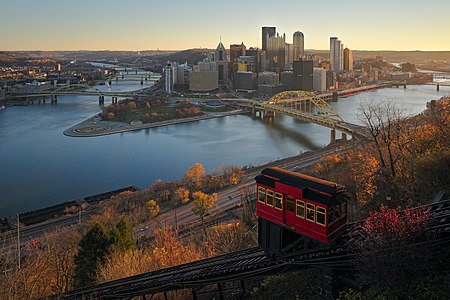
Downtown Pittsburgh from Duquesne Incline in the morning

The Duquesne Incline () is a funicular located near Pittsburgh's South Side neighborhood and scaling Mt. Washington in Pittsburgh, Pennsylvania, United States. Designed by Hungarian-American engineer Samuel Diescher, the incline was completed in 1877. The lower station is in the Second Empire style. Together with the incline, which rises 400 feet (122 m) in height, at a 30-degree angle, it was listed on the National Register of Historic Places in 1975. The incline is unusual for having a track gauge standard used only in Finland, Russia, and Mongolia. Together with the Monongahela Incline, it is one of two passenger inclines still in operation on Pittsburgh's South Side. By 1977, the two had become tourist attractions and together served more than one million commuters and tourists annually. That year both inclines were designated as Historic Mechanical Engineering Landmarks by the American Society of Mechanical Engineers (ASME).

Excerpt from the Wikipedia article Duquesne Incline (License: CC BY-SA 3.0, Authors, Images).

Duquesne Incline
West Carson Street, Pittsburgh

Geographical coordinates (GPS) Address Nearby Places
placeShow on map

Wikipedia: Duquesne InclineContinue reading on Wikipedia

Geographical coordinates (GPS)

Latitude Longitude
N 40.439166666667 ° E -80.018055555556 °
placeShow on map

Address

Duquesne Lower Station

West Carson Street
15211 Pittsburgh
Pennsylvania, United States
mapOpen on Google Maps

Downtown Pittsburgh from Duquesne Incline in the morning
Share experience

Nearby Places

Fort Pitt Tunnel
Fort Pitt Tunnel

The Fort Pitt Tunnel is a vehicular tunnel under Mount Washington in Pittsburgh, Pennsylvania. It connects the West End region on the southwest side to the South Shore neighborhood on the northeast side. The adjoining Fort Pitt Bridge on the northeast end connects to Downtown Pittsburgh. The tunnel carries traffic on Interstate 376 (I-376), U.S. Route 22 (US 22), US 30, and US 19 Truck. The structure comprises two bores, each with two lanes of traffic. The inbound tunnel flows onto the top deck of the double-deck Fort Pitt Bridge, opposite traffic from the lower deck using the outbound tunnel. To accommodate the bridge, the northeast portals of the parallel tunnels are vertically staggered by 30 feet. The tunnel opened in September 1960, a year after the Fort Pitt Bridge.Before entering the southwest end of the inbound tunnel, travelers see a commonplace view of Southwestern Pennsylvania's hills, but at the northeast end, travelers emerge to a panorama of Downtown Pittsburgh and the surrounding skyline. The view was cited by The New York Times as "the best way to enter an American city". The vantage was the inspiration for the news opening on Pittsburgh's KDKA-TV for several years in the 1980s and 1990s, and is referenced in Stephen Chbosky's novel The Perks of Being a Wallflower. The Fort Pitt Tunnel is the third-longest automobile tunnel in Pittsburgh, following the Liberty Tunnels and the Squirrel Hill Tunnel. It is one of four major tunnels passing beneath Mount Washington, including the Liberty Tunnels and the Wabash Tunnel for automobiles, and the Mount Washington Transit Tunnel for public transportation.