Dowdeswell
Civil parishes in GloucestershireCotswold DistrictGloucestershire geography stubs

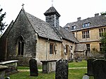
Dowdeswell is a civil parish in the ward of Chedworth, Cotswold, in the ceremonial county of Gloucestershire, England. It is separated into Upper and Lower Dowdeswell, the former being south of the latter. The population of the civil parish at the 2011 census was 134.About 7.1 km (4.4 mi) to the northwest is Cheltenham, and 19 km (12 mi) to the west is Gloucester. In 2001, it had a population of 185. The Church of Saint Michael and All Saints is a Grade I listed building.
Excerpt from the Wikipedia article Dowdeswell (License: CC BY-SA 3.0, Authors, Images).Dowdeswell
A40, Cotswold District Dowdeswell
Geographical coordinates (GPS) Address Nearby Places Show on map
Geographical coordinates (GPS)
| Latitude | Longitude |
|---|---|
| N 51.881111111111 ° | E -2.0033333333333 ° |
Address
A40
GL54 4HG Cotswold District, Dowdeswell
England, United Kingdom
Open on Google Maps


