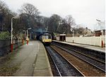
Strines railway station
1866 establishments in EnglandDfT Category F2 stationsFormer Great Central and Midland Joint Railway stationsGreater Manchester railway station stubsNorthern franchise railway stations ... and 4 more
Pages with no open date in Infobox stationRailway stations in Great Britain opened in 1866Railway stations in the Metropolitan Borough of StockportUse British English from November 2017

Strines railway station serves the village of Strines, in the Metropolitan Borough of Stockport, on the outskirts of Greater Manchester, England. Until boundary changes in 1994, the station itself lay over the border in Derbyshire.
Excerpt from the Wikipedia article Strines railway station (License: CC BY-SA 3.0, Authors, Images).Strines railway station
Station Road,
Geographical coordinates (GPS) Address External links Nearby Places Show on map
Geographical coordinates (GPS)
| Latitude | Longitude |
|---|---|
| N 53.375 ° | E -2.033 ° |
Address
Strines
Station Road
SK22 3AL
England, United Kingdom
Open on Google Maps


