place

Samuel Crockett House

Hall-parlor plan architecture in TennesseeHouses completed in 1808Houses in Williamson County, TennesseeHouses on the National Register of Historic Places in TennesseeNational Register of Historic Places in Williamson County, Tennessee
ForgeSeat
ForgeSeat

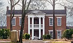
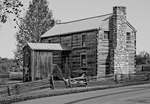
The Samuel Crockett House, also known as Forge Seat, is a property in Brentwood, Tennessee, United States, that was listed on the National Register of Historic Places in 1988. It was home of Samuel Crockett, son of Andrew Crockett, whose home is also NRHP-listed as Andrew Crockett House. When listed the property included five contributing buildings, one non-contributing building, and one non-contributing structure, on an area of 18.5 acres (7.5 ha). Andrew Crocket, Samuel's father, received a 640-acre (260 ha) grant for Revolutionary War services. He built his first log home on the southeast side of what is now Brentwood in 1799. His son, Samuel Crockett built a two-story brick home nearby, which was completed ca. 1808. The home became known as "Forge Seat" because of the iron forge located on the property. Samuel Crockett and his son, Andrew, made iron implements here and specialized in rifle making. Crockett's rifles "were identified by their fine craftsmanship and the initials 'S. & A. C.' engraved on the barrels." On his way to New Orleans and the War of 1812, Andrew Jackson stopped here and purchased rifles to arm his soldiers. It is also said that Davy Crockett stopped on his way to Texas as well.Samuel and Andrew Crockett and other family members are buried in the cemetery nearby.The log building containing the forge and the seat of the stone forge itself still remain. There has been no other early blacksmith or forge site found in the county.

Excerpt from the Wikipedia article Samuel Crockett House (License: CC BY-SA 3.0, Authors, Images).

Samuel Crockett House
Wilson Pike,

Geographical coordinates (GPS) Address Nearby Places
placeShow on map

Wikipedia: Samuel Crockett HouseContinue reading on Wikipedia

Geographical coordinates (GPS)

Latitude Longitude
N 35.975 ° E -86.775 °
placeShow on map

Address

Wilson Pike

Wilson Pike
37014
Tennessee, United States
mapOpen on Google Maps

ForgeSeat
ForgeSeat
Share experience

Nearby Places

Ravenswood (Brentwood, Tennessee)

Ravenswood is a historic property in Brentwood, Tennessee. Ravenswood was built by James Hazard Wilson II between 1821 and 1825. It was named to honor Sam Houston, the best man at Wilson's wedding. Houston was known as "the Raven" to the Cherokee. Ravenswood was listed on the National Register of Historic Places in 1983. In 2010, the city of Brentwood acquired the surrounding acreage and created Marcelle Vivrette Smith Park, which in 2014 became the largest park in Brentwood. After creating the park, the city restored the grounds and opened Ravenswood mansion for tours and special events.The plantation was one of several homes owned by the Wilson family. It comprised more than 1,000 acres and was one of the largest in Williamson County prior to the Civil War. Records from the 1860 census show that there were 55 enslaved people at Ravenswood. The plantation contained as many as 13 cabins for enslaved people, and the Wilson family also had enslaved people at their plantations in Louisiana and Mississippi. At the outbreak of the Civil War, Wilson hosted one of the area's two Confederate training camps at his Midway Plantation, which today is the Brentwood County Club.In 2010, the city of Brentwood purchased Ravenswood and the surrounding 325 acres, agreeing to name the resulting park as Marcella Vivrette Smith Park. In 2013, the city purchased an additional 80 acres to add to the park. It is now the largest park in Brentwood.The property includes Greek Revival and Federal architecture. When listed on the NRHP, the property included five contributing buildings and three non-contributing buildings on an area of 52 acres (21 ha).

Nashville Basin

The Nashville Basin, also known as the Central Basin, is a term often used to describe the area surrounding Murfreesboro, Tennessee, in which Nashville is located. The Central Basin was caused by an uplifting which produced a dome known as the Nashville Dome. The Nashville Dome is evidenced by the underlying rock strata that all dip downward away from Nashville. The uplifting of the Nashville Dome fractured overlying strata, making it more easily eroded, and thus the "dome" resulted in a "basin". Uplifted strata in the center of a geological dome have higher potential erosive energy than the surrounding strata, because they are physically higher. Erosion thus acts on the uplifted area at a greater rate than on the surrounding flat-lying area, creating a low area, i.e., a basin. This area is more correctly referred to as the "Central Dome" of Tennessee. Nashville is located in the northwestern portion of the Central Basin. The basin extends for approximately forty-five to sixty miles to the east of Nashville and about eighty miles to the south, near the Tennessee–Alabama state line. Travelers leaving Nashville in a northerly or easterly direction will soon begin the climb up the escarpment that marks the bordering geographic/geologic province, the Highland Rim and further eastwards, the Cumberland Plateau. The southern edge of the Highland Rim is more distant and somewhat less pronounced. The only downhill routes leaving the area follow the course of the Cumberland River as it flows northwest toward Ashland City and Clarksville, Tennessee. The Central Basin is underlain primarily by limestone from the Ordovician Period. The Nashville Basin and a similar but smaller area surrounding Lexington, Kentucky referred to as the "Kentucky Bluegrass" area, are the two primary areas of this sort in the world.The Inner Basin of the flattest terrain and most limestone-derived soil chemistry is located to the south and east of Nashville, primarily in the counties of Marshall, Rutherford, Wilson, and Bedford. Here also are seen the horse farms somewhat reminiscent of the Kentucky Bluegrass region. Supposedly the underlying rock weathers to a soil particularly suited to the growing of the sorts of grasses most favored by horses. Limestone glades (or cedar glades), located to the east of Nashville, primarily in Wilson and Rutherford Counties, are open areas where the flat limestone rock is denuded of overlying soil or nearly so, provide an environment for flora unlike any other in the world.