Land Yeo
ClevedonEngvarB from September 2013North SomersetRivers of Somerset

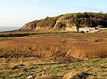
The Land Yeo is a small river which flows through North Somerset, England. It rises on Dundry Hill and supplies Barrow Gurney Reservoirs before flowing through various villages to Clevedon where it drains into the Severn Estuary. During the past 1,000 years it has powered at least ten watermills, however only one is still functional. Since 2003 initiatives have been undertaken to clean up the river, improving water quality and encouraging wildlife.
Excerpt from the Wikipedia article Land Yeo (License: CC BY-SA 3.0, Authors, Images).Land Yeo
Lower Strode Road,
Geographical coordinates (GPS) Address Phone number Website Nearby Places Show on map
Geographical coordinates (GPS)
| Latitude | Longitude |
|---|---|
| N 51.428333333333 ° | E -2.8758333333333 ° |
Address
Clevedon Golf Centre
Lower Strode Road
BS21 6UU , West End
England, United Kingdom
Open on Google Maps


