Ponter's Ball Dyke
Ancient dikesArchaeological sites in SomersetGlastonburyLinear earthworksScheduled monuments in Mendip District

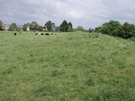
Ponter's Ball Dyke is a linear earthwork located near Glastonbury in Somerset, England. It crosses, at right angles, an ancient road that continues on to the Isle of Avalon. It consists of an embankment with a ditch on the east side. It is built across the ridge of land between Glastonbury and West Pennard. Both ends of the ditch and dyke disappear into moorland, formerly swamps.The current visible remains extend to just over 1 kilometre. It is bisected by the A361 and crossed by three public footpaths. The gap where the road runs through the dyke is staggered, suggesting that the gap is original.
Excerpt from the Wikipedia article Ponter's Ball Dyke (License: CC BY-SA 3.0, Authors, Images).Ponter's Ball Dyke
Edgarley Road,
Geographical coordinates (GPS) Address Nearby Places Show on map
Geographical coordinates (GPS)
| Latitude | Longitude |
|---|---|
| N 51.138032 ° | E -2.668244 ° |
Address
Edgarley Road
Edgarley Road
BA6 8FG
England, United Kingdom
Open on Google Maps


