Punta Maroma
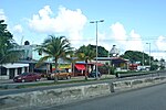
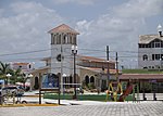
Punta Maroma is a beach located in Mexico's easternmost state, Quintana Roo, on the Yucatán Peninsula. The beach of Punta Maroma faces the Caribbean Sea. Punta Maroma beach is located in Solidaridad Municipality at 20°44′16″N 86°58′03″W. It is located inside the tourist district known as the Riviera Maya, along the coastal Highway 307 which parallels the Caribbean. It is 35.3 kilometres (21.9 mi) km from the Cancún International Airport (CUN) and about 10 kilometres (6.2 mi) northeast of Playa del Carmen. It had a population of 58 inhabitants during the 2010 census. Known for its white sand coastline and crystal-clear waters and its coral reef, that is part of the Mesoamerican Barrier Reef System, the second longest one in the world.
Excerpt from the Wikipedia article Punta Maroma (License: CC BY-SA 3.0, Authors).Punta Maroma
Carretera Federal, Solidaridad
Geographical coordinates (GPS) Address Nearby Places Show on map
 Continue reading on Wikipedia
 Geographical coordinates (GPS)
| Latitude | Longitude |
|---|---|
| N 20.730277777778 ° | E -86.965 ° |
Address
Carretera Federal
Solidaridad
Quintana Roo, Mexico
Open on Google Maps