place

Alderwasley

Civil parishes in DerbyshireDerbyshire geography stubsGeography of Amber ValleyVillages in Derbyshire
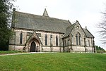
All Saints Church Alderwasley (geograph 3903347)

Alderwasley ( AL-ərz-LEE) is a village and civil parish in the Amber Valley district of Derbyshire, England. The population of the civil parish as of the 2011 census was 469. Alderwasley Hall is the home to one of the sites of Alderwasley Hall School which is a special school for children and young people with Aspergers and/or Speech and Language Difficulties. It is about six miles north of Belper. The village's name derives from the Old English for "clearing near alluvial land growing with alders". In the Middle Ages, it was a manor within Duffield Frith and contained the Royal Park of Shining Cliff Woods and a later park was formed to the south called Bradley Laund. In 1284 the Shining Cliff was given to William Foun by Edmund Crouchback, Earl of Lancaster. Foun was given the job of maintaining the boundaries between the Pendleton and Peatpits Brooks. This passed to Thomas Lowe by marriage in 1471. His son Anthony Lowe, as gentleman of the bedchamber for Henry VIII, was made a hereditary forester of Duffield Frith in 1523, and awarded the Manor of Alderwasley, with Ashleyhay, in 1528. In 1670 the whole estate passed, again by marriage, to Nicholas Hurt of Casterne in Staffordshire, a direct descendant of William Foun, and in 1715 he formed a new park. In 1905 this contained a herd of eighty fallow deer and what was considered to be the finest timber, especially oak, to be found. However, the estate was sold and broken up in the 1920s.The village has a reputation for its findings of silver treasure, namely coin clippings. The church plate of Alderwasley (a chalice, paten, flagon, and alms dish) were made from clippings of Charles I silver coins weighing 8lb, dug up in Bacon Meadow on 27 March 1846, according to a label on an earthenware jar in which the clippings had been hidden. Further clippings were uncovered by three brothers in their garden in the village, as recorded on a BBC Blue Peter programme in 1971.

Excerpt from the Wikipedia article Alderwasley (License: CC BY-SA 3.0, Authors, Images).

Alderwasley
Derby Old Road, Amber Valley

Geographical coordinates (GPS) Address Nearby Places
placeShow on map

Wikipedia: AlderwasleyContinue reading on Wikipedia

Geographical coordinates (GPS)

Latitude Longitude
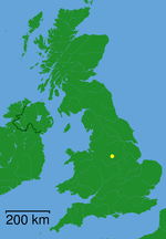
N 53.07 ° E -1.53 °
placeShow on map

Address

Derby Old Road

Derby Old Road
DE56 2RF Amber Valley
England, United Kingdom
mapOpen on Google Maps

All Saints Church Alderwasley (geograph 3903347)
Share experience

Nearby Places

Shining Cliff Woods, Derbyshire

Shining Cliff Woods are on the west bank of the River Derwent near to Ambergate in Derbyshire, England. In medieval times "Schymynde-cliffe" was one of the seven royal parks within Duffield Frith and, as such, belonged to Edmund Crouchback, Earl of Lancaster. It was an estate within the manor of Alderwasley and in 1284 was given to William Foun who was given the job of maintaining the boundaries between the Pendleton and Peatpits Brooks. They passed to Thomas Lowe by marriage in 1471 and in 1514 he was granted by Henry VIII the right to "empark and empale" his estate and enjoy "free warren" within it.The woods include an SSSI. Some of the woodland is owned and managed by Grith Fyrd Pioneers, but the Eastern part is (like Alport Height some 2 kilometres (1.2 mi) to the west), in the ownership of the National Trust, and part of their South Peak Estate. This woodland is managed by Forestry England. The woods contain a popular residential centre, once managed by the Youth Hostels Association but managed independently since 2009. The hostel stands in the lee of the Shining Cliff itself, a low gritstone rockface (grid reference SK333523). To the east of Shining Cliff Wood stands Oakhurst House, a 19th-century Jacobean-Arts and Crafts country home which has fallen into partial ruin. It was built by Francis Hurt, landowner and resident of local Alderwasley Hall. The house is in private ownership and not accessible to the public.

Shottle
Shottle

Shottle is a village approximately 3 miles (4.8 km) south of the market town of Wirksworth in Derbyshire. The population of the civil parish (Shottle and Postern) at the 2011 Census was 266.In Norman times, the manor of Shottle, referred to as Sothille in the Domesday Survey, belonged to the Ferrers family. In 1086, the book notes that "In Shottle and Wallstone Gamal had six carucates of land to the geld. There is land for as many ploughs. There are now one ploughs in demesne and three villans and three bordars having one ploughs and five acres of meadow. Woodland pasture 3 and a half leagues by one and a half leagues. (TRE worth ten shillings now ten shillings. Godric holds it" Shottle Park was one of the seven parks within Duffield Frith. The gate at its south-east corner is still known as Shottle Gate. To the south was the much smaller Postern Park. The present-day parish is known as Shottle and Postern. It was annexed to the Duchy of Lancaster after the rebellion by Robert de Ferrers, 6th Earl of Derby. It is thought to have passed to the Earl of Shrewsbury during the reign of Queen Elizabeth I. It was sold in 1630 by Philip, Earl of Pembroke and Montgomery, to Christian, the wife of William Cavendish, 2nd Earl of Devonshire.Shottle is a rather straggling rural village spread out on the road from Shottlegate to Wirksworth via Alport Height (Chequer Lane). Its main industry was, and remains, agriculture. Shottle Hall dates from 1841 and is a pleasant building in the late Georgian style, now used mainly for weddings and events. Whilst some way out of the village itself, Shottle has its own railway station – called Shottle after Shottle Hall, which is nearby. The station, which is on the Wirksworth Branch, was closed in 1947 to passengers and the building is owned by Peak Oil Ltd. The railway line has been reopened to passengers as the Ecclesbourne Valley Railway.

Leawood Pump House
Leawood Pump House

The Leawood Pump House (also known as High Peak Pump House) was built near Cromford, Derbyshire, England in 1849 to supply water to the Cromford Canal, built some 50 years previously. It is a Grade II* listed building. Located a little along the canal towpath from High Peak Junction, it stands to a height of 45 feet (14 m) on the right bank of the River Derwent, at the end of the Derwent Aqueduct, and has a 95-foot (29 m) chimney stack with a cast-iron cap. The Watt-type beam engine was designed and erected by Graham and Company of Milton Works, Elsecar, Sheffield. The beam length is 33 feet (10 m), the piston diameter 50 inches (1.3 m), stroke of 10 feet (3.0 m) and the engine works at 7 strokes per minute. The boilers, replaced in 1900, have a pressure of 40 p.s.i. Water is drawn from the River Derwent through a 150-yard (140 m) tunnel to a reservoir in the basement. It is then lifted 30 feet (9.1 m) and discharged into the canal. The immense size of the pump (which can transfer almost four tons of water per stroke and seven strokes a minute, a total of over 39,000 tons of water per 24 hours) is explained by the fact that there were restrictions on removing water from the Derwent river, this being allowed only between 8 p.m. on Saturdays and 8 p.m. on Sundays. The pumphouse worked continuously from 1849 until 1944 when the canal closed. It was restored in 1979 by the Cromford Canal Society and is run periodically.