Nørre Voldgade
Streets in Copenhagen

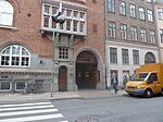
Nørre Voldgade (lit. "North Rampart Street") is a street in central Copenhagen, Denmark. It runs north-east from Jarmers Plads for approximately 600 metres to Gothersgade where it turns into Øster Voldgade. The succession of Nørre Voldgade, Øster Voldgade and Vester Voldgade together forms a traffic artery which arches around the Zealand side of the central and oldest part of Copenhagen. Nørreport Station, Denmark's busiest railway station, is located in the street.
Excerpt from the Wikipedia article Nørre Voldgade (License: CC BY-SA 3.0, Authors, Images).Nørre Voldgade
Nørre Voldgade, Copenhagen Christianshavn
Geographical coordinates (GPS) Address Nearby Places Show on map
Geographical coordinates (GPS)
| Latitude | Longitude |
|---|---|
| N 55.681944444444 ° | E 12.570277777778 ° |
Address
Babas Bagel & Salads (Bagel Store)
Nørre Voldgade
1358 Copenhagen, Christianshavn
Capital Region of Denmark, Denmark
Open on Google Maps


