place

Holywell, Lincolnshire

Hamlets in LincolnshireHoly wells in EnglandSouth Kesteven DistrictUse British English from February 2014
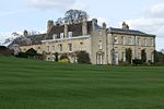
Holywell Hall Geograph 1238070 by Wendy Parkinson

Holywell is a tiny settlement in the civil parish of Careby Aunby and Holywell, in the South Kesteven district of Lincolnshire, England. It lies 5.5 miles (9 km) north from Stamford and 6 miles (10 km) south-west from Bourne. It is a collection of houses around a country house and park. The park includes a small private church dedicated to St Wilfrid. Ornamental lakes have been restored over the last 20 years, and new gardens laid out. In 2009 the gardens were open to the public through the National Garden Scheme. Two venerated springs are reported in the village, Holy Well and St Winifred's. Only the location of the first is known. There are no other place names associated with venerated springs in Lincolnshire, although other Holy Wells exist such as those near the site of Sempringham Priory and nearby Ryhall.

Excerpt from the Wikipedia article Holywell, Lincolnshire (License: CC BY-SA 3.0, Authors, Images).

Holywell, Lincolnshire
Castle Bytham Road, South Kesteven Careby Aunby and Holywell

Geographical coordinates (GPS) Address Nearby Places
placeShow on map

Wikipedia: Holywell, LincolnshireContinue reading on Wikipedia

Geographical coordinates (GPS)

Latitude Longitude
N 52.732285 ° E -0.51531 °
placeShow on map

Address

Home Farm House

Castle Bytham Road
PE9 4DT South Kesteven, Careby Aunby and Holywell
England, United Kingdom
mapOpen on Google Maps

Holywell Hall Geograph 1238070 by Wendy Parkinson
Share experience

Nearby Places

St Medardus and St Gildardus Church, Little Bytham

The church of St Medardus and St Gildardus in Little Bytham, Lincolnshire, England, is a Grade I listed building. It is dedicated to two 6th-century French saints, St Medard and St Gildard (or Medardus and Gildardus); the dedication is unique in the UK. Virtually unknown in Britain, St Medard is still well known in France, with at least 25 towns or villages named after him (as St Médard or St Méard). Gildard, thought to be his brother, is less well known. The village fête is held annually on or near St Medard's feast day, 8 June. The earliest parts of the building are some Anglo-Saxon "long-and-short" stonework, visible externally at the southeast and southwest corners (quoins) of the nave. The church also has several Romanesque details dating from the Norman era, including a Priest's Door ("uncommonly ornate", according to Nikolaus Pevsner) with a finely carved tympanum; the empty circular niche in the tympanum is said to have held a relic; the birds in roundels to either side are probably eagles, as one is legendarily supposed to have sheltered Medard from the rain. Also Norman are the plain, undecorated arch into the tower, and the north door (late 12th century). The south aisle and the upper parts of the tower and spire are 13th century work; the intersecting tracery of the east window of the south aisle shows that it is slightly later, dating from around 1300, as does the nearby piscina. The chancel arch is probably also from the late 13th century, and the double piscina in the chancel may be of a similar age. The Easter Sepulchre in the chancel is in the slightly later (Decorated) style, but is a fairly crude example. A finely sculpted capital depicting a Green Man surrounded by oak leaves, similar to examples at nearby Kirkby Underwood and Greatford, also dates from c.1300. It is no longer in position, having been built into a wall, face inwards, and rediscovered during later restoration work.The stone base of the pulpit is dated 1590, and has a Latin inscription Orate et parate ("Pray and prepare"). Pevsner mistakenly gives this as Orate et Arate. The Listed Building entry is taken from Pevsner, with the same error.The churchyard contains the war grave of a Royal Engineers soldier of the First World War.

Pickworth, Rutland
Pickworth, Rutland

Pickworth is a civil parish and small village in the county of Rutland. The population of the civil parish at the 2001 census was 81. This remained less than 100 at the 2011 census and was included in the town of Stamford.The village's name means 'enclosure of Pica'.In the 13th century Pickworth was quite a substantial village, but by the end of the 14th century it was almost non-existent. It now comprises a small parish church, a disused Methodist chapel, a few large houses and a couple of rows of terraced and council houses. It lies in a landscape characterised by Rutland County Council as the clay woodlands of the Rutland Plateau (a Jurassic limestone plateau). At the southern boundary of the village is a crossroads leading to Great Casterton about three miles (5 km) to the south, the A1 road at Tickencote Warren to the west, Lincolnshire Gate and Castle Bytham to the north and an unmaintained track to Ryhall Heath to the east. All Saints' Church, Pickworth was built in 1821 and lies to the west of the village. The church is a Grade II listed building. Maps previously showed the spire of the demolished church under the name Mockbeggar to the west of the current village site. The remains of the old medieval village lie mainly to the west of the current village centre in an area referred to as Top Pickworth. The only visible remains, other than earthworks, is a stone arch.Just to the west of the village lie the remains of a lime kiln. In 1817 this was the workplace of local poet John Clare. About two miles (3 km) south-east is Walk Farm, formerly known as Walkherd Lodge, which was the home of Martha "Patty" Turner, who became John Clare's wife. Both the lime kiln and Walk Farm featured in a television documentary that was made about the poet in the late 1960s. About two miles (3 km) to the west of the village is the site of the Battle of Losecote Field in 1470. It has been claimed that the village was depopulated as a result of the fighting.