Barrigada, Guam

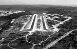
Barrigada (Chamorro: Barigåda) is a village in the United States territory of Guam. A largely residential municipality, its main village is located south of the Antonio B. Won Pat International Airport near the intersections of Routes 8, 10, and 16. The community east of the airport known as Barrigada Heights is considered an affluent neighborhood on the island, where homes have excellent views overlooking much of Guam including the island's airport and hotels along Tumon Bay. Another significant location is Mount Barrigada, nearly 200 meters above sea level. Its location in the center of the island means it houses most of the island's radio masts and towers; the position and height make it easier for radio signals to reach the entire island.
Excerpt from the Wikipedia article Barrigada, Guam (License: CC BY-SA 3.0, Authors, Images).Barrigada, Guam
San Roke Drive,
Geographical coordinates (GPS) Address Nearby Places Show on map
 Continue reading on Wikipedia
 Geographical coordinates (GPS)
| Latitude | Longitude |
|---|---|
| N 13.468333333333 ° | E 144.79888888889 ° |
Address
San Roke Drive
San Roke Drive
96921
Guam, United States
Open on Google Maps