place

Sweetwater Dam

1888 establishments in CaliforniaBuildings and structures in San Diego County, CaliforniaCuyamaca MountainsDam failures in the United StatesDams completed in 1888
Dams in CaliforniaHistoric Civil Engineering LandmarksMasonry damsUnited States local public utility dams
SweetwaterDamByPhilKonstantin

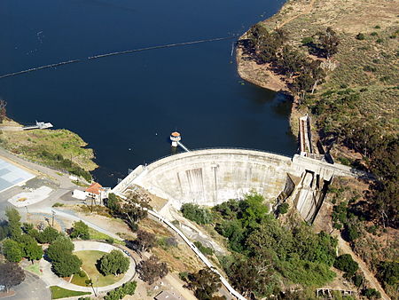
The Sweetwater Dam is a dam across the Sweetwater River in San Diego County, California. It is located approximately 12 miles (19 km) east of San Diego, 9 miles (14 km) and borders Bonita to the southwest and La Presa to the northeast. The 108-foot (33 m)-high masonry arch dam impounds 960-acre (390 ha) Sweetwater Reservoir. The dam was first constructed in 1888 as part of a system of reservoirs on San Diego County rivers designed to provide water to irrigate crops along the coast and to supply the city of San Diego and its outlying towns. Over the next few decades the dam was raised and retrofitted several times from its original height of 60 feet (18 m). In 1916, a heavy flood caused both abutments of the dam to fail. The rest of the dam did not sustain heavy damage and it remains in use for flood control, water storage and recreation.

Excerpt from the Wikipedia article Sweetwater Dam (License: CC BY-SA 3.0, Authors, Images).

Sweetwater Dam
Ranza Road,

Geographical coordinates (GPS) Address Nearby Places
placeShow on map

Wikipedia: Sweetwater DamContinue reading on Wikipedia

Geographical coordinates (GPS)

Latitude Longitude
N 32.691388888889 ° E -117.00805555556 °
placeShow on map

Address

Ranza Road 8715
91977
California, United States
mapOpen on Google Maps

SweetwaterDamByPhilKonstantin
Share experience

Nearby Places

Sweetwater Dam Naval Outlying Landing Field

Sweetwater Dam Naval Outlying Landing Field was a airfield near Naval Auxiliary Air Station Brown Field and Naval Air Station North Island used to support the training of US Navy pilots during World War 2. The runway built in 1944 was located in what is now a neighborhood 8 mile east of San Diego, California. The Navy support airfields are called Naval Outlying Landing Field (NOLF). For the war, many new trained pilots were needed. The Naval Outlying Landing Field provided a place for pilots to practice landing and take off without other air traffic. Sweetwater Dam site offered flight training without distractions. Most of the new pilots departed to the Pacific War after training. The Sweetwater Dam Outlying Landing Field had no support facilities. After the war the Outlying field closed in 1946, having completed the role of training new pilots. Sweetwater Dam Naval Outlying Landing Field and Sweetwater Carrier Landing Strip. The Landing Field had a single 3,000-foot east/west asphalt runway. The Navy leased 135.45 acres of grassland from Rancho de la Nación for the Landing Field. In 1949 the runway became a private civil airport, the Sweetwater Dam Airport also called the Paradise Mesa Airstrip. The Airport is named after the nearby Sweetwater Dam that makes the Sweetwater Reservoir. The Airport closed in 1951 and the runway became home to the Paradise Mesa Drag strip. The Carlsbad, California's Oilers Club help start the drag strip with the first meet on March 11, 1951. At its peak, 25 clubs were using the strip. The drag strip closed in 1959. Houses were built on the site, now called Paradise Hills and no trace of the runway can be found today. Part of the site is also the Daniel Boone Elementary School.